
Rumst topographic map
Interactive map
Click on the map to display elevation.
About this map
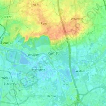
Name: Rumst topographic map, elevation, terrain.
Location: Rumst, Antwerpen, Vlaanderen, 2840, België (51.03929 4.38405 51.11929 4.46405)
Average elevation: 10 m
Minimum elevation: -2 m
Maximum elevation: 32 m
Other topographic maps
Click on a map to view its topography, its elevation and its terrain.