
Fontao topographic map
Interactive map
Click on the map to display elevation.
About this map
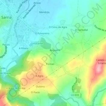
Name: Fontao topographic map, elevation, terrain.
Location: Fontao, Sarria, Lugo, Galicia, España (42.76285 -7.40938 42.77568 -7.38711)
Average elevation: 460 m
Minimum elevation: 415 m
Maximum elevation: 559 m
Other topographic maps
Click on a map to view its topography, its elevation and its terrain.
O Peruscallo
España > Galicia > Sarria > Sarria
O Peruscallo, Belante, Sarria, Lugo, Galicia, 27612, España
Average elevation: 648 m
Santo André de Paradela
España > Galicia > Sarria > Sarria
Santo André de Paradela, Sarria, Lugo, Galicia, España
Average elevation: 578 m
San Vicenzo
España > Galicia > Sarria > Sarria > San Vicenzo
San Vicenzo, Maside, Sarria, Galicia, 27619, España
Average elevation: 520 m