
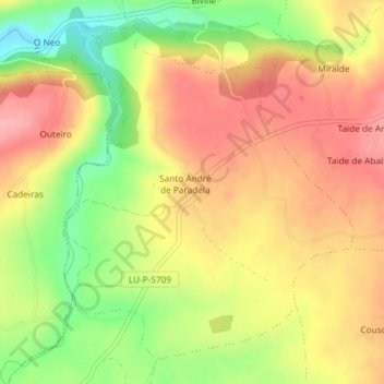
Santo André de Paradela topographic map
Interactive map
Click on the map to display elevation.
About this map
Name: Santo André de Paradela topographic map, elevation, terrain.
Location: Santo André de Paradela, Sarria, Lugo, Galicia, España (42.74671 -7.51337 42.77034 -7.48546)
Average elevation: 578 m
Minimum elevation: 514 m
Maximum elevation: 624 m
Other topographic maps
Click on a map to view its topography, its elevation and its terrain.
O Peruscallo
España > Galicia > Sarria > Sarria
O Peruscallo, Belante, Sarria, Lugo, Galicia, 27612, España
Average elevation: 648 m
San Vicenzo
España > Galicia > Sarria > Sarria > San Vicenzo
San Vicenzo, Maside, Sarria, Galicia, 27619, España
Average elevation: 520 m