
Lower Saxony topographic map
Interactive map
Click on the map to display elevation.
About this map
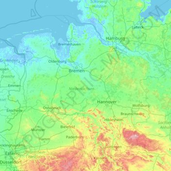
Name: Lower Saxony topographic map, elevation, terrain.
Location: Lower Saxony, Germany (51.29242 6.34591 54.13873 11.59812)
Average elevation: 87 m
Minimum elevation: -6 m
Maximum elevation: 1,047 m
The highest mountain in Lower Saxony is the Wurmberg (971 m) in the Harz. For other significant elevations see: List of mountains and hills in Lower Saxony. Most of the mountains and hills are found in the southeastern part of the state. The lowest point in the state, at about 2.5 m below sea level, is a depression near Freepsum in East Frisia.
Other topographic maps
Click on a map to view its topography, its elevation and its terrain.
Bruchhausen-Vilsen
Germany > Lower Saxony > Landkreis Diepholz
Bruchhausen-Vilsen, Samtgemeinde Bruchhausen-Vilsen, Landkreis Diepholz, Lower Saxony, 27305, Germany
Average elevation: 34 m
Lilienthal
Germany > Lower Saxony > Landkreis Osterholz
Lilienthal, Landkreis Osterholz, Lower Saxony, 28865, Germany
Average elevation: 4 m
Elbe
Germany > Lower Saxony > Elbe
Elbe, Samtgemeinde Baddeckenstedt, Landkreis Wolfenbüttel, Lower Saxony, 38274, Germany
Average elevation: 142 m
Diepholz
Germany > Lower Saxony > Diepholz
Diepholz, Landkreis Diepholz, Lower Saxony, 49356, Germany
Average elevation: 41 m
Dannenberg
Germany > Lower Saxony > Dannenberg
Dannenberg, Samtgemeinde Elbtalaue, Lüchow-Dannenberg, Lower Saxony, 29451, Germany
Average elevation: 22 m
Goslar
Germany > Lower Saxony > Goslar
Goslar, Landkreis Goslar, Lower Saxony, Germany
Average elevation: 311 m
Wunstorf
Germany > Lower Saxony > Wunstorf
Wunstorf, Region Hannover, Lower Saxony, 31515, Germany
Average elevation: 47 m
Innenstadt
Germany > Lower Saxony > Osnabrück
Innenstadt, Osnabrück, Lower Saxony, 49074, Germany
Average elevation: 72 m
Hoya
Germany > Lower Saxony > Hoya
Hoya, Samtgemeinde Grafschaft Hoya, Landkreis Nienburg/Weser, Lower Saxony, Germany
Average elevation: 18 m
Sehnde
Germany > Lower Saxony > Sehnde
Sehnde, Region Hannover, Lower Saxony, 31319, Germany
Average elevation: 66 m
Maar
Maar, Landkreis Aurich, Lower Saxony, 26529, Germany
Average elevation: 1 m