
Fulton topographic map
Interactive map
Click on the map to display elevation.
About this map
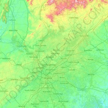
Name: Fulton topographic map, elevation, terrain.
Location: Fulton, Georgia, 30009, Estados Unidos (33.35804 -84.99613 34.75804 -83.59613)
Average elevation: 320 m
Minimum elevation: 133 m
Maximum elevation: 1,281 m
Other topographic maps
Click on a map to view its topography, its elevation and its terrain.
Berrien County
Berrien County, Georgia, Estados Unidos
Average elevation: 74 m
Augusta
Estados Unidos > Georgia > Augusta
Augusta, Richmond County, Georgia, Estados Unidos
Average elevation: 89 m
Webster County
Webster County, Georgia, Estados Unidos
Average elevation: 146 m