
Berrien County topographic map
Interactive map
Click on the map to display elevation.
About this map
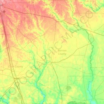
Name: Berrien County topographic map, elevation, terrain.
Location: Berrien County, Georgia, Estados Unidos (31.02550 -83.43963 31.47602 -83.03467)
Average elevation: 74 m
Minimum elevation: 41 m
Maximum elevation: 118 m
Other topographic maps
Click on a map to view its topography, its elevation and its terrain.
Augusta
Estados Unidos > Georgia > Augusta
Augusta, Richmond County, Georgia, Estados Unidos
Average elevation: 89 m
Webster County
Webster County, Georgia, Estados Unidos
Average elevation: 146 m