
Gansevoort topographic map
Interactive map
Click on the map to display elevation.
About this map
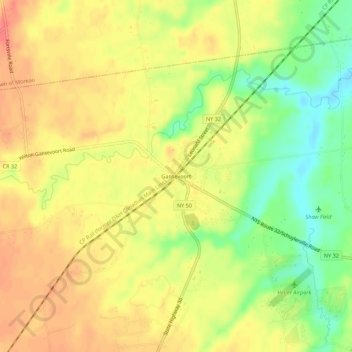
Name: Gansevoort topographic map, elevation, terrain.
Average elevation: 69 m
Minimum elevation: 37 m
Maximum elevation: 91 m
Other topographic maps
Click on a map to view its topography, its elevation and its terrain.
Saratoga Springs
United States > New York > Saratoga County > Saratoga Springs
Saratoga Springs, City of Saratoga Springs, Saratoga County, New York, 12866, United States
Average elevation: 161 m
Town of Clifton Park
United States > New York > Saratoga County
Town of Clifton Park, Saratoga County, New York, United States
Average elevation: 85 m
North Greenfield
United States > New York > Saratoga County
North Greenfield, Town of Greenfield, Saratoga County, New York, 12859, United States
Average elevation: 209 m
Town of Greenfield
United States > New York > Saratoga County
Town of Greenfield, Saratoga County, New York, United States
Average elevation: 251 m
Riverside
United States > New York > Saratoga County > Town of Stillwater
Riverside, Town of Stillwater, Saratoga County, New York, 12170, United States
Average elevation: 50 m
Town of Halfmoon
United States > New York > Saratoga County
Town of Halfmoon, Saratoga County, New York, 12118, United States
Average elevation: 73 m
Village of Ballston Spa
United States > New York > Saratoga County
Village of Ballston Spa, Town of Milton, Saratoga County, New York, 12020, United States
Average elevation: 97 m
Hagedorns Mills
United States > New York > Saratoga County
Hagedorns Mills, Town of Providence, Saratoga County, New York, United States
Average elevation: 314 m
Town of Hadley
United States > New York > Saratoga County
Town of Hadley, Saratoga County, New York, United States
Average elevation: 302 m
Town of Charlton
United States > New York > Saratoga County
Town of Charlton, Saratoga County, New York, United States
Average elevation: 175 m
Vischer Ferry
United States > New York > Saratoga County > Town of Clifton Park
Vischer Ferry, Town of Clifton Park, Saratoga County, New York, 12309, United States
Average elevation: 74 m
Greenfield Center
United States > New York > Saratoga County
Greenfield Center, Town of Greenfield, Saratoga County, New York, 12833, United States
Average elevation: 204 m
Village of Waterford
United States > New York > Saratoga County
Village of Waterford, Town of Waterford, Saratoga County, New York, United States
Average elevation: 22 m
Town of Milton
United States > New York > Saratoga County
Town of Milton, Saratoga County, New York, United States
Average elevation: 117 m
Quaker Springs
United States > New York > Saratoga County
Quaker Springs, Town of Saratoga, Saratoga County, New York, United States
Average elevation: 102 m
City of Saratoga Springs
United States > New York > Saratoga County
City of Saratoga Springs, Saratoga County, New York, 12866, United States
Average elevation: 97 m
Ballston Center
United States > New York > Saratoga County
Ballston Center, Town of Ballston, Saratoga County, New York, 12019, United States
Average elevation: 105 m
Clifton Park
United States > New York > Saratoga County > Clifton Park
Clifton Park, Town of Clifton Park, Saratoga County, New York, 12065-4370, United States
Average elevation: 94 m
Kings
United States > New York > Saratoga County
Kings, Town of Greenfield, Saratoga County, New York, 12833, United States
Average elevation: 205 m
Town of Malta
United States > New York > Saratoga County
Town of Malta, Saratoga County, New York, 12151, United States
Average elevation: 91 m
Town of Ballston
United States > New York > Saratoga County
Town of Ballston, Saratoga County, New York, United States
Average elevation: 118 m
Town of Day
United States > New York > Saratoga County
Town of Day, Saratoga County, New York, 12835, United States
Average elevation: 446 m
Town of Corinth
United States > New York > Saratoga County
Town of Corinth, Saratoga County, New York, 12822, United States
Average elevation: 278 m
Village of Round Lake
United States > New York > Saratoga County > Town of Malta
Village of Round Lake, Town of Malta, Saratoga County, New York, 12151, United States
Average elevation: 62 m
Village of Stillwater
United States > New York > Saratoga County
Village of Stillwater, Town of Stillwater, Saratoga County, New York, United States
Average elevation: 42 m
Village of South Glens Falls
United States > New York > Saratoga County
Village of South Glens Falls, Town of Moreau, Saratoga County, New York, 12803, United States
Average elevation: 96 m
Halfmoon
United States > New York > Saratoga County > Halfmoon
Halfmoon, Town of Halfmoon, Saratoga County, New York, 12065, United States
Average elevation: 84 m
Hadley
United States > New York > Saratoga County > Hadley
Hadley, Town of Hadley, Saratoga County, New York, 12846, United States
Average elevation: 227 m
City of Mechanicville
United States > New York > Saratoga County
City of Mechanicville, Saratoga County, New York, United States
Average elevation: 38 m
Gates
United States > New York > Saratoga County > Gates
Gates, Town of Saratoga, Saratoga County, New York, 12871, United States
Average elevation: 82 m
North Ballston Spa
United States > New York > Saratoga County > Town of Milton
North Ballston Spa, Town of Milton, Saratoga County, New York, United States
Average elevation: 106 m
Bailey Hill
United States > New York > Saratoga County
Bailey Hill, Town of Greenfield, Saratoga County, New York, United States
Average elevation: 217 m
Elnora
United States > New York > Saratoga County > Town of Clifton Park > Elnora
Elnora, Town of Clifton Park, Saratoga County, New York, 12019, United States
Average elevation: 98 m
Ushers Road State Forest
United States > New York > Saratoga County
Ushers Road State Forest, Town of Clifton Park, Saratoga County, New York, United States
Average elevation: 63 m
Milton
United States > New York > Saratoga County > Milton
Milton, Town of Milton, Saratoga County, New York, United States
Average elevation: 125 m
Saratoga Lake
United States > New York > Saratoga County > Town of Malta
Saratoga Lake, Town of Malta, Town of Saratoga, Saratoga County, New York, United States
Average elevation: 82 m
Devils Den
United States > New York > Saratoga County
Devils Den, Town of Greenfield, Saratoga County, New York, United States
Average elevation: 186 m
Town of Moreau
United States > New York > Saratoga County
Town of Moreau, Saratoga County, New York, United States
Average elevation: 115 m