
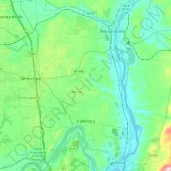
Town of Halfmoon topographic map
Interactive map
Click on the map to display elevation.
About this map
Name: Town of Halfmoon topographic map, elevation, terrain.
Average elevation: 73 m
Minimum elevation: 0 m
Maximum elevation: 331 m
Halfmoon is a town in Saratoga County, New York, United States. The population was 25,662 at the 2020 census. The town is apparently named for the shape of the lower elevation land north of the junction of the Hudson and Mohawk Rivers. It is also said to be named for Henry Hudson's ship, the Halve Maen.
Other topographic maps
Click on a map to view its topography, its elevation and its terrain.
Saratoga Springs
United States > New York > Saratoga County > Saratoga Springs
Saratoga Springs, City of Saratoga Springs, Saratoga County, New York, 12866, United States
Average elevation: 161 m
Town of Clifton Park
United States > New York > Saratoga County
Town of Clifton Park, Saratoga County, New York, United States
Average elevation: 85 m
North Greenfield
United States > New York > Saratoga County
North Greenfield, Town of Greenfield, Saratoga County, New York, 12859, United States
Average elevation: 209 m
Town of Greenfield
United States > New York > Saratoga County
Town of Greenfield, Saratoga County, New York, United States
Average elevation: 251 m
Riverside
United States > New York > Saratoga County > Town of Stillwater
Riverside, Town of Stillwater, Saratoga County, New York, 12170, United States
Average elevation: 50 m
Village of Ballston Spa
United States > New York > Saratoga County
Village of Ballston Spa, Town of Milton, Saratoga County, New York, 12020, United States
Average elevation: 97 m
Hagedorns Mills
United States > New York > Saratoga County
Hagedorns Mills, Town of Providence, Saratoga County, New York, United States
Average elevation: 314 m
Town of Hadley
United States > New York > Saratoga County
Town of Hadley, Saratoga County, New York, United States
Average elevation: 302 m
Town of Charlton
United States > New York > Saratoga County
Town of Charlton, Saratoga County, New York, United States
Average elevation: 175 m
Vischer Ferry
United States > New York > Saratoga County > Town of Clifton Park
Vischer Ferry, Town of Clifton Park, Saratoga County, New York, 12309, United States
Average elevation: 74 m
Greenfield Center
United States > New York > Saratoga County
Greenfield Center, Town of Greenfield, Saratoga County, New York, 12833, United States
Average elevation: 204 m
Village of Waterford
United States > New York > Saratoga County
Village of Waterford, Town of Waterford, Saratoga County, New York, United States
Average elevation: 22 m
Gansevoort
United States > New York > Saratoga County
Gansevoort, Town of Northumberland, Saratoga County, New York, United States
Average elevation: 69 m
Town of Milton
United States > New York > Saratoga County
Town of Milton, Saratoga County, New York, United States
Average elevation: 117 m
Quaker Springs
United States > New York > Saratoga County
Quaker Springs, Town of Saratoga, Saratoga County, New York, United States
Average elevation: 102 m
City of Saratoga Springs
United States > New York > Saratoga County
City of Saratoga Springs, Saratoga County, New York, 12866, United States
Average elevation: 97 m
Ballston Center
United States > New York > Saratoga County
Ballston Center, Town of Ballston, Saratoga County, New York, 12019, United States
Average elevation: 105 m
Clifton Park
United States > New York > Saratoga County > Clifton Park
Clifton Park, Town of Clifton Park, Saratoga County, New York, 12065-4370, United States
Average elevation: 94 m
Kings
United States > New York > Saratoga County
Kings, Town of Greenfield, Saratoga County, New York, 12833, United States
Average elevation: 205 m
Town of Malta
United States > New York > Saratoga County
Town of Malta, Saratoga County, New York, 12151, United States
Average elevation: 91 m
Town of Ballston
United States > New York > Saratoga County
Town of Ballston, Saratoga County, New York, United States
Average elevation: 118 m
Town of Day
United States > New York > Saratoga County
Town of Day, Saratoga County, New York, 12835, United States
Average elevation: 446 m
Town of Corinth
United States > New York > Saratoga County
Town of Corinth, Saratoga County, New York, 12822, United States
Average elevation: 278 m
Village of Round Lake
United States > New York > Saratoga County > Town of Malta
Village of Round Lake, Town of Malta, Saratoga County, New York, 12151, United States
Average elevation: 62 m
Village of Stillwater
United States > New York > Saratoga County
Village of Stillwater, Town of Stillwater, Saratoga County, New York, United States
Average elevation: 42 m
Village of South Glens Falls
United States > New York > Saratoga County
Village of South Glens Falls, Town of Moreau, Saratoga County, New York, 12803, United States
Average elevation: 96 m
Halfmoon
United States > New York > Saratoga County > Halfmoon
Halfmoon, Town of Halfmoon, Saratoga County, New York, 12065, United States
Average elevation: 84 m
Hadley
United States > New York > Saratoga County > Hadley
Hadley, Town of Hadley, Saratoga County, New York, 12846, United States
Average elevation: 227 m
City of Mechanicville
United States > New York > Saratoga County
City of Mechanicville, Saratoga County, New York, United States
Average elevation: 38 m
Gates
United States > New York > Saratoga County > Gates
Gates, Town of Saratoga, Saratoga County, New York, 12871, United States
Average elevation: 82 m
North Ballston Spa
United States > New York > Saratoga County > Town of Milton
North Ballston Spa, Town of Milton, Saratoga County, New York, United States
Average elevation: 106 m
Bailey Hill
United States > New York > Saratoga County
Bailey Hill, Town of Greenfield, Saratoga County, New York, United States
Average elevation: 217 m
Elnora
United States > New York > Saratoga County > Town of Clifton Park > Elnora
Elnora, Town of Clifton Park, Saratoga County, New York, 12019, United States
Average elevation: 98 m
Ushers Road State Forest
United States > New York > Saratoga County
Ushers Road State Forest, Town of Clifton Park, Saratoga County, New York, United States
Average elevation: 63 m
Milton
United States > New York > Saratoga County > Milton
Milton, Town of Milton, Saratoga County, New York, United States
Average elevation: 125 m
Saratoga Lake
United States > New York > Saratoga County > Town of Malta
Saratoga Lake, Town of Malta, Town of Saratoga, Saratoga County, New York, United States
Average elevation: 82 m
Town of Moreau
United States > New York > Saratoga County
Town of Moreau, Saratoga County, New York, United States
Average elevation: 115 m
Devils Den
United States > New York > Saratoga County
Devils Den, Town of Greenfield, Saratoga County, New York, United States
Average elevation: 186 m