
Fès topographic map
Interactive map
Click on the map to display elevation.
About this map
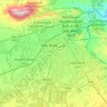
Name: Fès topographic map, elevation, terrain.
Location: Fès, Pachalik du Fes, Préfecture de Fès, Fès-Meknès, Maroc (33.97643 -5.07818 34.07551 -4.93771)
Average elevation: 432 m
Minimum elevation: 212 m
Maximum elevation: 832 m
Other topographic maps
Click on a map to view its topography, its elevation and its terrain.
arrondissement de Fès-Médina
Maroc > Pachalik du Fes > Fès
arrondissement de Fès-Médina, Fès, Pachalik du Fes, Préfecture de Fès, Fès-Meknès, Maroc
Average elevation: 344 m