
Make a donation
Canada topographic map
Click on the map to display elevation.
Make a donation
Canada
Canada's topography is a diverse tapestry shaped by its vast landscapes and geological history. Dominating nearly half of the country, the Canadian Shield is a massive expanse of ancient, eroded rocks, characterized by a rugged terrain dotted with countless lakes and rivers. To the west, the majestic Rocky Mountains rise sharply, featuring some of the nation's highest peaks and deep valleys carved by glacial activity. In contrast, the central provinces are home to the Interior Plains, expansive flatlands that stretch between the Shield and the Rockies, known for their fertile soils and prairie landscapes. The eastern region encompasses the Appalachian Mountains, an older and more eroded range presenting rolling hills and rich forests. Along the southern edge, the Great Lakes–St. Lawrence Lowlands offer fertile plains that support a significant portion of Canada's agriculture and urban development. In the far north, the Arctic Archipelago consists of a labyrinth of islands and peninsulas, characterized by permafrost and tundra, presenting a stark yet captivating landscape. This intricate blend of mountains, plains, forests, and tundra defines Canada's varied terrain.
Make a donation
About this map
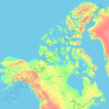
Name: Canada topographic map, elevation, terrain.
Location: Canada (41.67656 -141.00275 83.33621 -52.32377)
Average elevation: 254 m
Minimum elevation: -2 m
Maximum elevation: 4,944 m
Make a donation
Other topographic maps
Click on a map to view its topography, its elevation and its terrain.
Mutare
Zimbabwe > Manicaland Province > Mutare
Despite its tropical location, the city has a humid subtropical climate, of the highland variety moderated by its altitude. Mutare experiences drizzle almost throughout the year. The average annual temperature is 19 °C, surprisingly low for its moderate altitude (about the same as Harare which is 360 metres…
Average elevation: 1,160 m
Soweto
South Africa > Gauteng > City of Johannesburg Metropolitan Municipality
Average elevation: 1,638 m
Victoria Falls
Zimbabwe > Matabeleland North Province > Hwange > Victoria Falls Municipality
Average elevation: 918 m
Make a donation
Dullstroom
South Africa > Mpumalanga > Nkangala > Emakhazeni Local Municipality
Due to its high elevation (Dullstroom being the highest town in South Africa itself), Dullstroom has a subtropical highland climate (Köppen: Cwb). From October to April, the town sees a significant amount of rainfall (higher than nearby Johannesburg to the west), in contrast with winter, where precipitation…
Average elevation: 2,009 m
Sabie
South Africa > Mpumalanga > Ehlanzeni District Municipality > Thaba Chweu Local Municipality
Average elevation: 1,150 m
Mpuluzi
South Africa > Mpumalanga > Gert Sibande > Albert Luthuli Local Municipality
Average elevation: 1,458 m
Make a donation
Medina
Saudi Arabia > Medina Province
Medina is located in the Hejaz region which is a 200 km (120 mi) wide strip between the Nafud desert and the Red Sea. Located approximately 720 km (450 mi) northwest of Riyadh which is at the centre of the Saudi desert, the city is 250 km (160 mi) away from the west coast of Saudi Arabia and at an elevation of…
Average elevation: 692 m
Ďumbier
Slovakia > Region of Žilina > District of Liptovský Mikuláš > Liptovský Ján
Average elevation: 1,669 m
Make a donation
Make a donation
Pretoria
South Africa > Gauteng > City of Tshwane Metropolitan Municipality
Pretoria is situated approximately 56 km (35 mi) north-northeast of Johannesburg in the northeast of South Africa, in a transitional belt between the plateau of the Highveld to the south and the lower-lying Bushveld to the north. It lies at an altitude of about 1,339 m (4,393 ft) above sea level, in a warm,…
Average elevation: 1,363 m
Make a donation
Make a donation
Klima
Greece > Region of Crete > Heraklion Regional Unit > Tybakio Municipal Unit
Average elevation: 176 m
Stellenbosch
South Africa > Western Cape > Cape Winelands District Municipality > Stellenbosch Local Municipality
Stellenbosch is 53 km (33 mi) east of Cape Town via National Route N1. Stellenbosch is in a hilly region of the Cape Winelands, and is sheltered in a valley at an average elevation of 136 m (446 ft), flanked on the west by Papegaaiberg (Afrikaans: Parrot Mountain), which is actually a hill. To the south is…
Average elevation: 222 m
Make a donation
Livno
Bosnia and Herzegovina > Federation of Bosnia and Herzegovina > City of Livno
Average elevation: 907 m
Make a donation
Tuba
Tuba's topography is generally characterized by irregular rugged terrain and steep slopes with several mountain peaks rising from the table land itself. Mount Santo Tomas, the highest peak in the municipality soars to 2,252 metres (7,388 ft) above sea level.
Average elevation: 1,242 m
Huế
Vietnam > Huế > Thuận Hóa Ward
The Perfume River (called Sông Hương or Hương Giang in Vietnamese) passes through the center of the city. The city also accommodates the Tam Giang–Cau Hai lagoon, the largest lagoon in Southeast Asia, which is 68 kilometres (42 mi) long with a surface area of 220 square kilometres (85 sq mi). The city…
Average elevation: 30 m
Make a donation
Agoudal ou Souss
Morocco > Souss-Massa > Pachalik d'Ait Meloul ⵍⴱⴰⵛⴰⵡⵉⵢⴰ ⵏ ⴰⵢⵜ ⵎⴻⵍⵍⵓⵍ باشوية ايت ملول > Aït Melloul
Average elevation: 29 m
Make a donation
Make a donation
Reineberg
Germany > North Rhine-Westphalia > Kreis Minden-Lübbecke > Lübbecke
The Reineberg is a hill on the Wiehen ridge, south of the town of Lübbecke. With a height of 275.9 m above sea level it is, from a topographical point of view, not a particularly impressive eminence in this part of the Wiehen Hills, because, in the immediate vicinity are considerably higher summits, such as…
Average elevation: 181 m
Make a donation
Fort William
United Kingdom > Scotland > Highland
Fort William has an oceanic climate (Cfb) with moderate, but generally cool, temperatures and abundant precipitation. In the towns immediate vicinity, there are significant variations in elevation, which leads to some uninhabited areas near the town having a subpolar oceanic climate (Cfc), or, at the absolute…
Average elevation: 122 m
La Mata
Spain > Valencian Community > el Baix Segura / La Vega Baja > Torrevieja
Average elevation: 5 m
Make a donation
Make a donation
St. Francis Bay
South Africa > Eastern Cape > Sarah Baartman District Municipality > Kouga Local Municipality
Average elevation: 25 m
Perryville
United States > Pennsylvania > Westmoreland County > Bell Township
Average elevation: 365 m
Make a donation
Make a donation
Make a donation
Kohat
Pakistan > Khyber Pakhtunkhwa > Kohat District
Kohat city is located at an altitude of 489 metres (1,604 ft). Kohat Pass lies to the north. It is situated on the left bank of the Toi river at a point where after running nearly due east for 50 miles (80 km), it turns to the south. The total area of the district is 2,545 square kilometres (983 sq mi)
Average elevation: 722 m
Make a donation
Ghazni
Ghazni's climate is transitional between a cold semi-arid climate (Köppen climate classification BSk) and a hot-summer humid continental climate (Dsa). It has cold, snowy winters and warm, dry summers. Precipitation is low and mostly falls in winter (as snow) and spring (as rain). Winters are very cold, with…
Average elevation: 2,341 m
Faraya
Lebanon > Keserwan-Jbeil Governorate
Faraya (Arabic: فاريا) is a village and municipality in the Keserwan District of the Keserwan-Jbeil Governorate, Lebanon. It is located 46 kilometers north of Beirut. Elevation start from 1290 meters to 2000 meters above sea level and its total land area is 870 hectares. Faraya's inhabitants are…
Average elevation: 1,558 m
Make a donation
Make a donation
Algiers
Algeria > Algiers > Sidi M'Hamed District > Alger-Centre
The city's downtown sits at an elevation of 2 m (at the Algiers Central Post Office), while it averages 45 m across the city's metropolitan area, and tops at 407 m on the Bouzaréah peak. Algiers Province, the administrative area that includes the city's urban and suburban centers covers 1,190 km2 (460 sq mi).
Average elevation: 45 m
Guwahati
Professor Abani Kumar Bhagawati of Gauhati University stated that since before there were sufficient wetlands to absorb rainwater and channels to carry excess water to the Brahmaputra, the city did not experience floods. However, human interference has disrupted the natural topography, leading to the current…
Average elevation: 113 m
Make a donation
Großer Feldberg
Germany > Hesse > Hochtaunuskreis > Schmitten im Taunus
The Großer Feldberg ('Great Field Mountain') is, at a height of 879.5 metres, the highest elevation of the Taunus mountains, and of the entire Rhenish Massif. It is situated in the Hochtaunuskreis district in Hesse, Germany.
Average elevation: 716 m
Make a donation
The subdivision Mandariniers
Algeria > Algiers > Dar el-Beida District > Al Muhammadiyya > Pins Maritimes
Average elevation: 17 m
Make a donation
Make a donation
Make a donation