
Lattaquié topographic map
Interactive map
Click on the map to display elevation.
About this map
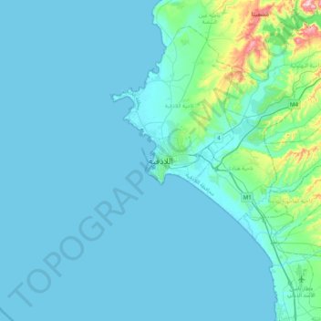
Name: Lattaquié topographic map, elevation, terrain.
Location: Lattaquié, ناحية اللاذقية, Syrie (35.36002 35.61810 35.68002 35.93810)
Average elevation: 28 m
Minimum elevation: -1 m
Maximum elevation: 325 m
Other topographic maps
Click on a map to view its topography, its elevation and its terrain.
منطقة اللاذقية
Syrie > Gouvernorat de Lattaquié
منطقة اللاذقية, Gouvernorat de Lattaquié, Syrie
Average elevation: 284 m