
Tulungagung topographic map
Interactive map
Click on the map to display elevation.
About this map
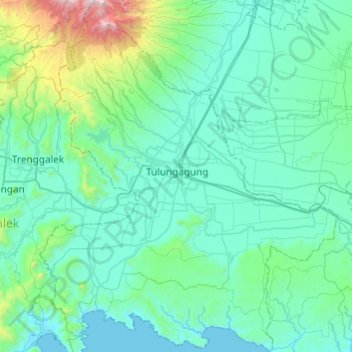
Name: Tulungagung topographic map, elevation, terrain.
Location: Tulungagung, East Java, Indonesia (-8.31252 111.71145 -7.83331 112.12202)
Average elevation: 263 m
Minimum elevation: -1 m
Maximum elevation: 2,265 m
Other topographic maps
Click on a map to view its topography, its elevation and its terrain.
Bono
Indonesia > East Java > Tulungagung
Bono, Tulungagung, East Java, 66234, Indonesia
Average elevation: 86 m