
Constantine topographic map
Interactive map
Click on the map to display elevation.
About this map
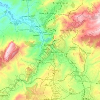
Name: Constantine topographic map, elevation, terrain.
Location: Constantine, Daïra Constantine, Constantine, Algérie (36.25893 6.52845 36.44909 6.76655)
Average elevation: 656 m
Minimum elevation: 293 m
Maximum elevation: 1,204 m
La ville s'étale sur un terrain caractérisé par une topographie très accidentée, marquée par une juxtaposition de plateaux, de collines, de dépressions et de ruptures brutales de pentes donnant ainsi un site hétérogène.
Other topographic maps
Click on a map to view its topography, its elevation and its terrain.
Ben Abdelmalek
Algérie > Constantine > Daïra Constantine > Constantine
Ben Abdelmalek, Constantine, Daïra Constantine, Constantine, 25100, Algérie
Average elevation: 622 m
El Manchar
Algérie > Constantine > Daïra Constantine > Constantine
El Manchar, Constantine, Daïra Constantine, Constantine, 25017, Algérie
Average elevation: 532 m