
Gisborne District topographic map
Interactive map
Click on the map to display elevation.
About this map
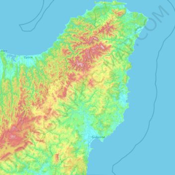
Name: Gisborne District topographic map, elevation, terrain.
Location: Gisborne District, Gisborne, New Zealand (-38.97281 177.12217 -37.53291 178.57815)
Average elevation: 228 m
Minimum elevation: 0 m
Maximum elevation: 1,644 m
Other topographic maps
Click on a map to view its topography, its elevation and its terrain.
Gisborne
New Zealand > Gisborne > Gisborne District
Gisborne, Gisborne District, Gisborne, 4010, New Zealand
Average elevation: 70 m
Waingake
New Zealand > Gisborne > Gisborne District
Waingake, Gisborne District, Gisborne, New Zealand
Average elevation: 166 m
Titirangi
New Zealand > Gisborne > Gisborne
Titirangi, Gisborne, 4020, New Zealand
Average elevation: 19 m
Whangaparāoa River
New Zealand > Gisborne > Ōpōtiki District
Whangaparāoa River, Ōpōtiki District, Gisborne, New Zealand
Average elevation: 191 m
Te Puia Springs
Te Puia Springs, Gisborne, 4079, New Zealand
Average elevation: 237 m