
Millers Mills topographic map
Interactive map
Click on the map to display elevation.
About this map
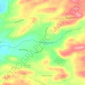
Name: Millers Mills topographic map, elevation, terrain.
Average elevation: 440 m
Minimum elevation: 374 m
Maximum elevation: 500 m
Other topographic maps
Click on a map to view its topography, its elevation and its terrain.
Elizabethtown
United States > New York > Herkimer County
Elizabethtown, Town of Columbia, Herkimer County, New York, 13357, United States
Average elevation: 392 m
Kingdom
United States > New York > Herkimer County > Town of Warren
Kingdom, Town of Warren, Herkimer County, New York, United States
Average elevation: 474 m
Getman Corners
United States > New York > Herkimer County
Getman Corners, Town of Columbia, Herkimer County, New York, United States
Average elevation: 446 m
Indian Castle
United States > New York > Herkimer County
Indian Castle, Town of Danube, Herkimer County, New York, United States
Average elevation: 152 m
Days Corners
United States > New York > Herkimer County > Town of Litchfield
Days Corners, Town of Litchfield, Herkimer County, New York, 13322, United States
Average elevation: 442 m
Columbia Center
United States > New York > Herkimer County
Columbia Center, Town of Columbia, Herkimer County, New York, United States
Average elevation: 475 m
East Frankfort
United States > New York > Herkimer County > Town of Frankfort
East Frankfort, Town of Frankfort, Herkimer County, New York, United States
Average elevation: 152 m
Harbor
United States > New York > Herkimer County > Town of Frankfort
Harbor, Town of Frankfort, Herkimer County, New York, 13504, United States
Average elevation: 156 m
Irish Settlement
United States > New York > Herkimer County
Irish Settlement, Town of Newport, Herkimer County, New York, United States
Average elevation: 371 m
Cedarville
United States > New York > Herkimer County
Cedarville, Town of Columbia, Herkimer County, New York, United States
Average elevation: 411 m
Frankfort Center
United States > New York > Herkimer County > Town of Frankfort
Frankfort Center, Town of Frankfort, Herkimer County, New York, 13340, United States
Average elevation: 288 m
South Columbia
United States > New York > Herkimer County
South Columbia, Town of Columbia, Herkimer County, New York, 13439, United States
Average elevation: 450 m
Woods Lake
United States > New York > Herkimer County
Woods Lake, Town of Webb, Herkimer County, New York, United States
Average elevation: 612 m
Corrado Corners
United States > New York > Herkimer County > Town of Frankfort
Corrado Corners, Town of Frankfort, Herkimer County, New York, 13340, United States
Average elevation: 170 m
Paines Hollow
United States > New York > Herkimer County
Paines Hollow, Town of Little Falls, Herkimer County, New York, United States
Average elevation: 378 m
Trenton Falls - Main Dam
United States > New York > Herkimer County > Town of Russia
Trenton Falls - Main Dam, Town of Russia, Herkimer County, New York, 13435, United States
Average elevation: 321 m
Village of Mohawk
United States > New York > Herkimer County > Town of German Flatts
Village of Mohawk, Town of German Flatts, Herkimer County, New York, United States
Average elevation: 148 m
Dennison Corners
United States > New York > Herkimer County > Town of German Flatts
Dennison Corners, Town of German Flatts, Herkimer County, New York, 13407, United States
Average elevation: 404 m
Edicks
United States > New York > Herkimer County > Town of German Flatts
Edicks, Town of German Flatts, Herkimer County, New York, United States
Average elevation: 355 m
South Ilion
United States > New York > Herkimer County > Town of German Flatts
South Ilion, Town of German Flatts, Herkimer County, New York, United States
Average elevation: 239 m
Norwich Corners
United States > New York > Herkimer County > Town of Litchfield
Norwich Corners, Town of Litchfield, Herkimer County, New York, 13456, United States
Average elevation: 385 m
McKeever
United States > New York > Herkimer County
McKeever, Town of Webb, Herkimer County, New York, United States
Average elevation: 500 m
Youngs Crossing
United States > New York > Herkimer County
Youngs Crossing, Town of Columbia, Herkimer County, New York, United States
Average elevation: 457 m
Newville
United States > New York > Herkimer County
Newville, Town of Danube, Herkimer County, New York, United States
Average elevation: 231 m
North Frankfort
United States > New York > Herkimer County > Town of Schuyler
North Frankfort, Town of Schuyler, Herkimer County, New York, 13357, United States
Average elevation: 177 m
Jacksonburg
United States > New York > Herkimer County
Jacksonburg, Town of Little Falls, Herkimer County, New York, United States
Average elevation: 197 m
Village of Poland
United States > New York > Herkimer County
Village of Poland, Town of Russia, Herkimer County, New York, United States
Average elevation: 251 m
North Columbia
United States > New York > Herkimer County
North Columbia, Town of Columbia, Herkimer County, New York, 13357, United States
Average elevation: 349 m
West Schuyler
United States > New York > Herkimer County > Town of Schuyler
West Schuyler, Town of Schuyler, Herkimer County, New York, 13504, United States
Average elevation: 144 m
East Creek
United States > New York > Herkimer County > Town of Manheim
East Creek, Town of Manheim, Herkimer County, New York, United States
Average elevation: 139 m
Ingham Mills
United States > New York > Herkimer County > Town of Manheim
Ingham Mills, Town of Manheim, Herkimer County, New York, 13329, United States
Average elevation: 215 m
Northwood
United States > New York > Herkimer County > Town of Russia
Northwood, Town of Russia, Herkimer County, New York, United States
Average elevation: 392 m
Thendara
United States > New York > Herkimer County
Thendara, Town of Webb, Herkimer County, New York, 13472, United States
Average elevation: 541 m
Chepachet
United States > New York > Herkimer County > Town of Winfield
Chepachet, Town of Winfield, Herkimer County, New York, United States
Average elevation: 408 m
Old City
United States > New York > Herkimer County > Town of Fairfield
Old City, Town of Fairfield, Herkimer County, New York, 13416, United States
Average elevation: 249 m
Stewart Corners
United States > New York > Herkimer County > Town of Frankfort
Stewart Corners, Town of Frankfort, Herkimer County, New York, United States
Average elevation: 392 m
West Frankfort
United States > New York > Herkimer County > Town of Frankfort
West Frankfort, Town of Frankfort, Herkimer County, New York, 13504, United States
Average elevation: 144 m
North Ilion
United States > New York > Herkimer County > Town of Herkimer
North Ilion, Town of Herkimer, Herkimer County, New York, 13357, United States
Average elevation: 169 m
Cranes Corners
United States > New York > Herkimer County > Town of Litchfield
Cranes Corners, Town of Litchfield, Herkimer County, New York, United States
Average elevation: 421 m
Farrel Corner
United States > New York > Herkimer County
Farrel Corner, Town of Newport, Herkimer County, New York, 13431, United States
Average elevation: 339 m
Hurricane
United States > New York > Herkimer County
Hurricane, Town of Norway, Herkimer County, New York, United States
Average elevation: 422 m
Gray
United States > New York > Herkimer County
Gray, Town of Ohio, Herkimer County, New York, United States
Average elevation: 403 m
Atwell
United States > New York > Herkimer County
Atwell, Town of Ohio, Herkimer County, New York, United States
Average elevation: 598 m
North Wilmurt
United States > New York > Herkimer County
North Wilmurt, Town of Ohio, Herkimer County, New York, United States
Average elevation: 520 m
Gravesville
United States > New York > Herkimer County > Town of Russia
Gravesville, Town of Russia, Herkimer County, New York, United States
Average elevation: 280 m
Wheelertown
United States > New York > Herkimer County > Town of Russia
Wheelertown, Town of Russia, Herkimer County, New York, United States
Average elevation: 424 m
Paper Mill Corners
United States > New York > Herkimer County > Town of Salisbury
Paper Mill Corners, Town of Salisbury, Herkimer County, New York, United States
Average elevation: 407 m
Salisbury Center
United States > New York > Herkimer County > Town of Salisbury
Salisbury Center, Town of Salisbury, Herkimer County, New York, United States
Average elevation: 334 m
Irondale
United States > New York > Herkimer County > Town of Salisbury
Irondale, Town of Salisbury, Herkimer County, New York, 13454, United States
Average elevation: 383 m
Johnson Corners
United States > New York > Herkimer County > Town of Schuyler
Johnson Corners, Town of Schuyler, Herkimer County, New York, United States
Average elevation: 230 m