
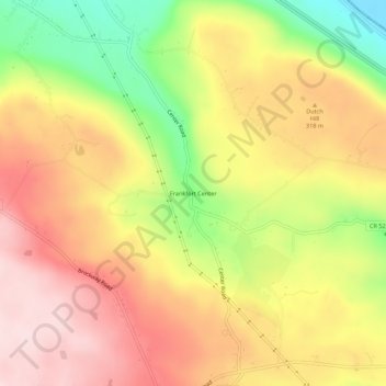
Frankfort Center topographic map
Interactive map
Click on the map to display elevation.
About this map
Name: Frankfort Center topographic map, elevation, terrain.
Average elevation: 288 m
Minimum elevation: 120 m
Maximum elevation: 415 m
Other topographic maps
Click on a map to view its topography, its elevation and its terrain.
East Frankfort
United States > New York > Herkimer County > Town of Frankfort
East Frankfort, Town of Frankfort, Herkimer County, New York, United States
Average elevation: 152 m
Harbor
United States > New York > Herkimer County > Town of Frankfort
Harbor, Town of Frankfort, Herkimer County, New York, 13504, United States
Average elevation: 156 m
Corrado Corners
United States > New York > Herkimer County > Town of Frankfort
Corrado Corners, Town of Frankfort, Herkimer County, New York, 13340, United States
Average elevation: 170 m
Stewart Corners
United States > New York > Herkimer County > Town of Frankfort
Stewart Corners, Town of Frankfort, Herkimer County, New York, United States
Average elevation: 392 m
West Frankfort
United States > New York > Herkimer County > Town of Frankfort
West Frankfort, Town of Frankfort, Herkimer County, New York, 13504, United States
Average elevation: 144 m
Gulph
United States > New York > Herkimer County > Town of Frankfort
Gulph, Town of Frankfort, Herkimer County, New York, United States
Average elevation: 388 m