
Thank you for supporting this site ❤️
Make a donation
Make a donation
Bendigo topographic map
Click on the map to display elevation.
Thank you for supporting this site ❤️
Make a donation
Make a donation
About this map
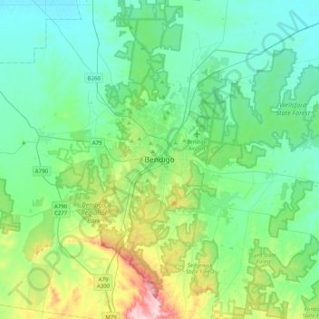
Name: Bendigo topographic map, elevation, terrain.
Average elevation: 223 m
Minimum elevation: 139 m
Maximum elevation: 535 m
Thank you for supporting this site ❤️
Make a donation
Make a donation
Other topographic maps
Click on a map to view its topography, its elevation and its terrain.
Albert Park
Australia > Victoria > Melbourne
Heritage Victoria notes that Albert Park's St Vincent Gardens "is historically important as the premier 'square' development in Victoria based on similar models in London. It is significant as the largest development of its type in Victoria and for its unusual development as gardens rather than the more usual…
Average elevation: 6 m
Thank you for supporting this site ❤️
Make a donation
Make a donation