
Thank you for supporting this site ❤️
Make a donation
Make a donation
Mansfield topographic map
Click on the map to display elevation.
Thank you for supporting this site ❤️
Make a donation
Make a donation
About this map
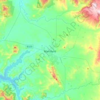
Name: Mansfield topographic map, elevation, terrain.
Location: Mansfield, Shire of Mansfield, Victoria, 3722, Australia (-37.14475 145.95084 -36.95364 146.24426)
Average elevation: 401 m
Minimum elevation: 255 m
Maximum elevation: 901 m
Thank you for supporting this site ❤️
Make a donation
Make a donation
Other topographic maps
Click on a map to view its topography, its elevation and its terrain.