
Tooele County topographic map
Interactive map
Click on the map to display elevation.
About this map
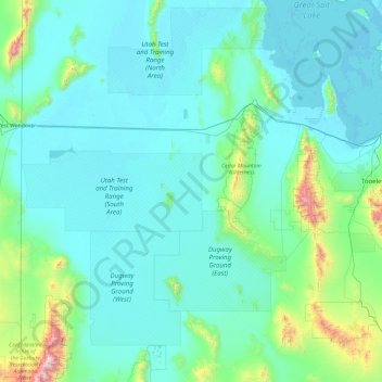
Name: Tooele County topographic map, elevation, terrain.
Location: Tooele County, Utah, USA (39.90358 -114.04838 41.07616 -112.14520)
Average elevation: 1,463 m
Minimum elevation: 1,279 m
Maximum elevation: 3,633 m
Other topographic maps
Click on a map to view its topography, its elevation and its terrain.
Timpanogos Glacier
USA > Utah > Aspen Grove
Timpanogos Glacier, Mount Timpanogos Trail #052, Aspen Grove, Utah County, Utah, USA
Average elevation: 3,148 m