
White Peak topographic map
Interactive map
Click on the map to display elevation.
About this map
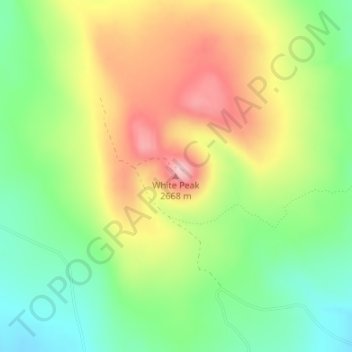
Name: White Peak topographic map, elevation, terrain.
Location: White Peak, Colfax County, Nieuw-Mexico, VS (36.29776 -105.02117 36.29786 -105.02107)
Average elevation: 2,574 m
Minimum elevation: 2,491 m
Maximum elevation: 2,676 m
Other topographic maps
Click on a map to view its topography, its elevation and its terrain.
Puesta Del Sol
VS > Nieuw-Mexico > Puesta Del Sol
Puesta Del Sol, Sandoval County, Nieuw-Mexico, 87043, VS
Average elevation: 1,807 m
Chaco Culture National Historical Park
Chaco Culture National Historical Park, Chaco Loop Road, San Juan County, Nieuw-Mexico, VS
Average elevation: 1,919 m
Santa Fe
VS > Nieuw-Mexico > Santa Fe
Santa Fe, Santa Fe County, Nieuw-Mexico, VS
Average elevation: 2,222 m
Los Alamos
VS > Nieuw-Mexico > Los Alamos
Los Alamos, Los Alamos County, Nieuw-Mexico, VS
Average elevation: 2,231 m