
Grand Rapids topographic map
Interactive map
Click on the map to display elevation.
About this map
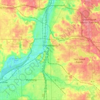
Name: Grand Rapids topographic map, elevation, terrain.
Location: Grand Rapids, Kent County, Michigan, États-Unis d'Amérique (42.88365 -85.75153 43.02905 -85.56865)
Average elevation: 216 m
Minimum elevation: 178 m
Maximum elevation: 257 m
La ville de Grand Rapids s’élève à 200 m d'altitude. Elle est située à environ 50 km à l’est du lac Michigan.
Other topographic maps
Click on a map to view its topography, its elevation and its terrain.
Cascade Charter Township
États-Unis d'Amérique > Michigan > Kent County
Cascade Charter Township, Kent County, Michigan, 49546, États-Unis d'Amérique
Average elevation: 229 m
Algoma Township
États-Unis d'Amérique > Michigan > Kent County
Algoma Township, Kent County, Michigan, États-Unis d'Amérique
Average elevation: 242 m