
Hoeselt topographic map
Interactive map
Click on the map to display elevation.
About this map
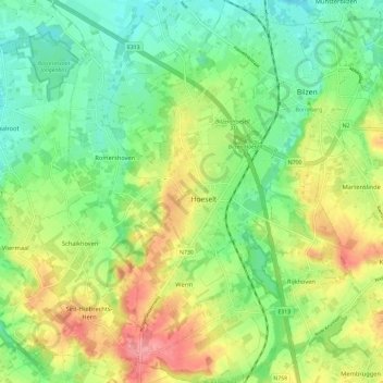
Name: Hoeselt topographic map, elevation, terrain.
Location: Hoeselt, Tongeren, Limburg, Vlaanderen, 3730, België (50.81441 5.44045 50.88843 5.51333)
Average elevation: 72 m
Minimum elevation: 37 m
Maximum elevation: 124 m
Other topographic maps
Click on a map to view its topography, its elevation and its terrain.
Alt-Hoeselt
België > Limburg > Tongeren > Hoeselt > Alt-Hoeselt
Alt-Hoeselt, Hoeselt, Tongeren, Limburg, Vlaanderen, 3730, België
Average elevation: 85 m