
Xares topographic map
Interactive map
Click on the map to display elevation.
About this map
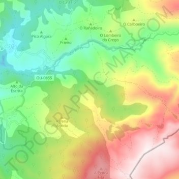
Name: Xares topographic map, elevation, terrain.
Location: Xares, A Veiga, Valdeorras, Orense, Galicia, 32365, España (42.20738 -6.95012 42.26444 -6.86986)
Average elevation: 1,273 m
Minimum elevation: 930 m
Maximum elevation: 1,759 m
Other topographic maps
Click on a map to view its topography, its elevation and its terrain.
Valdín
España > Galicia > Valdeorras > A Veiga
Valdín, A Veiga, Valdeorras, Orense, Galicia, España
Average elevation: 1,263 m
Lamalonga
España > Galicia > Valdeorras > A Veiga
Lamalonga, A Veiga, Valdeorras, Orense, Galicia, España
Average elevation: 1,274 m
Espiño
España > Galicia > Valdeorras > A Veiga
Espiño, A Veiga, Valdeorras, Orense, Galicia, España
Average elevation: 1,146 m
ZEC Pena Trevinca
España > Galicia > Valdeorras > A Veiga
ZEC Pena Trevinca, Valdín, A Veiga, Valdeorras, Orense, Galicia, 32369, España
Average elevation: 1,223 m
Carracedo
España > Galicia > Valdeorras > A Veiga
Carracedo, A Veiga, Valdeorras, Orense, Galicia, España
Average elevation: 927 m