
Gunnison County topographic map
Interactive map
Click on the map to display elevation.
About this map
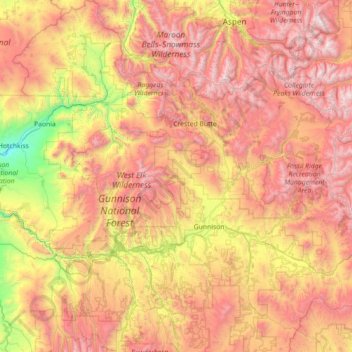
Name: Gunnison County topographic map, elevation, terrain.
Location: Gunnison County, Colorado, United States (38.14707 -107.63326 39.25769 -106.24563)
Average elevation: 2,892 m
Minimum elevation: 1,613 m
Maximum elevation: 4,388 m
Gunnison County is the fifth-most extensive of the 64 counties in the U.S. state of Colorado. As of the 2010 census, the population was 15,324. The county seat is Gunnison. The county was named for John W. Gunnison, a United States Army officer and captain in the Army Topographical Engineers, who surveyed for the transcontinental railroad in 1853.
Other topographic maps
Click on a map to view its topography, its elevation and its terrain.
Vail
United States > Colorado > Eagle County
Vail, Eagle County, Colorado, 81657, United States
Average elevation: 2,953 m
Cherry Ridge
United States > Colorado > Arapahoe County > Cherry Hills Village
Cherry Ridge, Cherry Hills Village, Arapahoe County, Colorado, 80113, United States
Average elevation: 1,680 m
Boulder
United States > Colorado > Boulder County
Boulder, Boulder County, Colorado, United States
Average elevation: 1,785 m
La Plata County
La Plata County, Colorado, United States
Average elevation: 2,527 m
Pikes Peak
United States > Colorado > El Paso County
Pikes Peak, El Paso County, Colorado, United States
Average elevation: 3,901 m
Montezuma County
Montezuma County, Colorado, United States
Average elevation: 2,025 m