
Pikes Peak topographic map
Interactive map
Click on the map to display elevation.
About this map
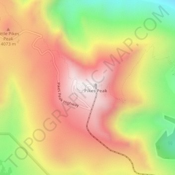
Name: Pikes Peak topographic map, elevation, terrain.
Location: Pikes Peak, El Paso County, Colorado, United States (38.84034 -105.04402 38.84044 -105.04392)
Average elevation: 3,901 m
Minimum elevation: 3,379 m
Maximum elevation: 4,301 m
Soils on Pikes Peak above the timberline (approximately 12,000 ft or 3,700 m) are classified as Cirque land. Forests at lower altitudes mostly lie over the brown stony, sandy, loams of the Catamount loam or Ivywild loam series.[6]