
Baglung topographic map
Interactive map
Click on the map to display elevation.
About this map
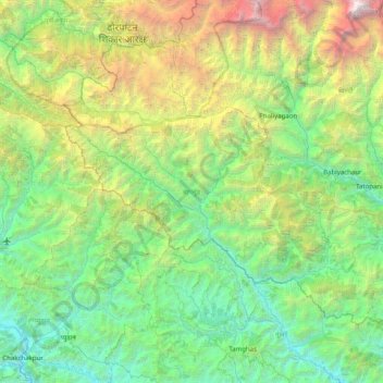
Name: Baglung topographic map, elevation, terrain.
Location: Baglung, Gandaki Province, Nepal (28.07739 82.87511 28.63544 83.67431)
Average elevation: 2,325 m
Minimum elevation: 527 m
Maximum elevation: 8,142 m
Baglung is surrounded by Parbat, Myagdi, Rukum, Rolpa, Pyuthan and Gulmi districts. It has 59 Village Development Committees and one Municipality. Baglung has the moniker "District of suspension bridges" as there are numerous suspension bridges. It is a hilly district, and most of the population settled on the sides of the rivers. Fertile plains situated on either side of the rivers are used for farming. The headquarters of Baglung District is Baglung Municipality which is located on a plateau overlooking the holy Kali Gandaki. Like Nepal, Baglung is also diverse in religion, culture, ethnicity, altitude, temperature etc. Hinduism and Buddhism are the major religions.
Other topographic maps
Click on a map to view its topography, its elevation and its terrain.
Malika
Nepal > Gandaki Province > Myagdi
Malika, Myagdi, Gandaki Province, 33208, Nepal
Average elevation: 2,161 m
Sarangkot
Nepal > Gandaki Province > Kaski > Pokhara
Sarangkot, Pokhara, Kaski, Gandaki Province, 00799, Nepal
Average elevation: 1,139 m
Phedikhola
Nepal > Gandaki Province > Syangja
Phedikhola, Phedhikhola-01, Phedhikhola, Syangja, Gandaki Province, 33808, Nepal
Average elevation: 1,193 m
Nyak
Nepal > Gandaki Province > Gorkha
Nyak, Chum Nubri, Gorkha, Gandaki Province, Nepal
Average elevation: 2,320 m
Chame
Nepal > Gandaki Province > Manang
Chame, Manang, Gandaki Province, Nepal
Average elevation: 4,025 m
Chum Nubri
Nepal > Gandaki Province > Gorkha
Chum Nubri, Gorkha, Gandaki Province, Nepal
Average elevation: 4,445 m
Muktinath
Nepal > Gandaki Province > Mustang > Ranipauwa
Muktinath, Barhagaun Muktikhsetra-01, Ranipauwa, Barhagaun Muktikhsetra, Mustang, Gandaki Province, 33100, Nepal
Average elevation: 3,965 m
Kihun
Nepal > Gandaki Province > Tanahun
Kihun, Bhimad, Tanahun, Gandaki Province, Nepal
Average elevation: 842 m
Poon Hill
Nepal > Gandaki Province > Myagdi > Ghorepani
Poon Hill, Ghorepani, Annapurna, Myagdi, Gandaki Province, 33200, Nepal
Average elevation: 2,873 m
Larjung
Nepal > Gandaki Province > Mustang
Larjung, Thasang, Mustang, Gandaki Province, Nepal
Average elevation: 2,764 m
Annapurna Conservation Area
Nepal > Gandaki Province > Manang
Annapurna Conservation Area, Neshyang-08, Neshyang, Manang, Gandaki Province, Nepal
Average elevation: 4,339 m
Phewa Lake
Nepal > Gandaki Province > Kaski > Pokhara
Phewa Lake, Pokhara-06, Pokhara, Kaski, Gandaki Province, Nepal
Average elevation: 884 m
Barpak
Nepal > Gandaki Province > Gorkha
Barpak, Sulikot, Gorkha, Gandaki Province, Nepal
Average elevation: 1,714 m
Annapurna
Nepal > Gandaki Province > Kaski
Annapurna, Kaski, Gandaki Province, 33711, Nepal
Average elevation: 2,974 m
Kapuche Glacier Lake
Nepal > Gandaki Province > Kaski
Kapuche Glacier Lake, Parche - Namarjung, Madi-02, Madi, Kaski, Gandaki Province, Nepal
Average elevation: 2,908 m
Pokhara
Nepal > Gandaki Province > Kaski
Pokhara, Kaski, Gandaki Province, Nepal
Average elevation: 1,203 m
Sundarbazar
Nepal > Gandaki Province > Lamjung
Sundarbazar, Lamjung, Gandaki Province, Nepal
Average elevation: 958 m
Byas
Nepal > Gandaki Province > Tanahun
Byas, Tanahun, Gandaki Province, Nepal
Average elevation: 664 m
Dhaulagiri
Nepal > Gandaki Province > Myagdi
Dhaulagiri, Myagdi, Gandaki Province, Nepal
Average elevation: 7,321 m