
Thank you for supporting this site ❤️
Make a donation
Make a donation
Kangaroo Island topographic map
Click on the map to display elevation.
Thank you for supporting this site ❤️
Make a donation
Make a donation
About this map
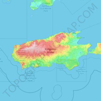
Name: Kangaroo Island topographic map, elevation, terrain.
Average elevation: 22 m
Minimum elevation: -1 m
Maximum elevation: 311 m
Thank you for supporting this site ❤️
Make a donation
Make a donation
Other topographic maps
Click on a map to view its topography, its elevation and its terrain.
Western River (South Branch)
Australia > South Australia > Kangaroo Island Council
Average elevation: 212 m