
Western River (South Branch) topographic map
Interactive map
Click on the map to display elevation.
About this map
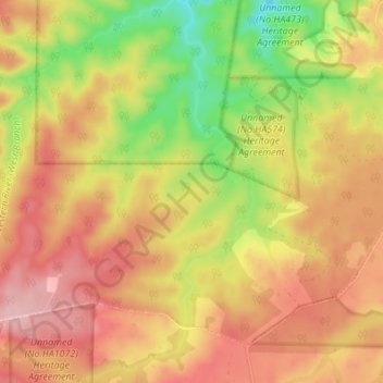
Name: Western River (South Branch) topographic map, elevation, terrain.
Average elevation: 212 m
Minimum elevation: 118 m
Maximum elevation: 282 m
Other topographic maps
Click on a map to view its topography, its elevation and its terrain.
Kangaroo Island
Australia > South Australia > Kangaroo Island Council
Kangaroo Island, Kangaroo Island Council, South Australia, Australia
Average elevation: 22 m
Whale Gully
Australia > South Australia > Kangaroo Island Council
Whale Gully, De Mole River, Kangaroo Island Council, South Australia, 5223, Australia
Average elevation: 49 m
Kingscote
Australia > South Australia > Kangaroo Island Council > Kingscote
Kingscote, Kangaroo Island Council, South Australia, 5223, Australia
Average elevation: 7 m