
Kvitfjell topographic map
Interactive map
Click on the map to display elevation.
About this map
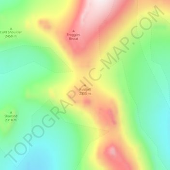
Name: Kvitfjell topographic map, elevation, terrain.
Location: Kvitfjell, Greenland (72.06595 -24.86513 72.06605 -24.86503)
Average elevation: 1,934 m
Minimum elevation: 1,679 m
Maximum elevation: 2,344 m
Other topographic maps
Click on a map to view its topography, its elevation and its terrain.
Jakobshavn Glacier
Jakobshavn Glacier, Avannaata, Greenland
Average elevation: 452 m
Geographical Society Island
Geographical Society Island, Sermersooq, Greenland
Average elevation: 178 m