
Horry County topographic map
Interactive map
Click on the map to display elevation.
About this map
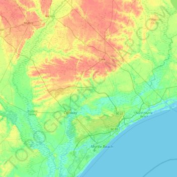
Name: Horry County topographic map, elevation, terrain.
Location: Horry County, South Carolina, United States (33.56912 -79.33546 34.29963 -78.54135)
Average elevation: 14 m
Minimum elevation: -5 m
Maximum elevation: 40 m
Other topographic maps
Click on a map to view its topography, its elevation and its terrain.
Lake Keowee
United States > South Carolina > Oconee County > Seneca
Lake Keowee, Seneca, Oconee County, South Carolina, 29672, United States
Average elevation: 292 m
Garden City
United States > South Carolina > Horry County > Garden City Beach
Garden City, Sullivan's Landing, Garden City Beach, Horry County, South Carolina, 29576, United States
Average elevation: 4 m
Georgetown County
United States > South Carolina > Georgetown County
Georgetown County, South Carolina, United States
Average elevation: 6 m
Awendaw
United States > South Carolina > Awendaw
Awendaw, Charleston County, South Carolina, United States
Average elevation: 1 m