
Make a donation
Bangladesh topographic map
Click on the map to display elevation.
Make a donation
Bangladesh
With an elevation of 1,064 m (3,491 ft), Saka Haphong (also known as Mowdok Mual) near the border with Myanmar, is claimed to be the highest peak of Bangladesh. However, it is not yet widely recognized as the highest point of the country, and most sources give the honor to Keokradong.
Make a donation
About this map
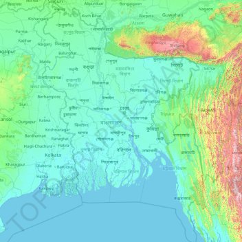
Name: Bangladesh topographic map, elevation, terrain.
Location: Bangladesh (20.36791 88.00792 26.63825 92.68020)
Average elevation: 161 m
Minimum elevation: -2 m
Maximum elevation: 2,636 m
Make a donation
Other topographic maps
Click on a map to view its topography, its elevation and its terrain.
Make a donation
Make a donation
Pretoria
South Africa > Gauteng > City of Tshwane Metropolitan Municipality
Pretoria is situated approximately 56 km (35 mi) north-northeast of Johannesburg in the northeast of South Africa, in a transitional belt between the plateau of the Highveld to the south and the lower-lying Bushveld to the north. It lies at an altitude of about 1,339 m (4,393 ft) above sea level, in a warm,…
Average elevation: 1,363 m
Make a donation
Klima
Greece > Region of Crete > Heraklion Regional Unit > Tybakio Municipal Unit
Average elevation: 176 m
Make a donation
Stellenbosch
South Africa > Western Cape > Cape Winelands District Municipality > Stellenbosch Local Municipality
Stellenbosch is 53 km (33 mi) east of Cape Town via National Route N1. Stellenbosch is in a hilly region of the Cape Winelands, and is sheltered in a valley at an average elevation of 136 m (446 ft), flanked on the west by Papegaaiberg (Afrikaans: Parrot Mountain), which is actually a hill. To the south is…
Average elevation: 222 m
Make a donation
Huế
Vietnam > Huế > Thuận Hóa Ward
The Perfume River (called Sông Hương or Hương Giang in Vietnamese) passes through the center of the city. The city also accommodates the Tam Giang–Cau Hai lagoon, the largest lagoon in Southeast Asia, which is 68 kilometres (42 mi) long with a surface area of 220 square kilometres (85 sq mi). The city…
Average elevation: 30 m
Agoudal ou Souss
Morocco > Souss-Massa > Pachalik d'Ait Meloul ⵍⴱⴰⵛⴰⵡⵉⵢⴰ ⵏ ⴰⵢⵜ ⵎⴻⵍⵍⵓⵍ باشوية ايت ملول > Aït Melloul
Average elevation: 29 m
Livno
Bosnia and Herzegovina > Federation of Bosnia and Herzegovina > City of Livno
Average elevation: 907 m
Make a donation
Tuba
Tuba's topography is generally characterized by irregular rugged terrain and steep slopes with several mountain peaks rising from the table land itself. Mount Santo Tomas, the highest peak in the municipality soars to 2,252 metres (7,388 ft) above sea level.
Average elevation: 1,242 m
Make a donation
Make a donation
Reineberg
Germany > North Rhine-Westphalia > Kreis Minden-Lübbecke > Lübbecke
The Reineberg is a hill on the Wiehen ridge, south of the town of Lübbecke. With a height of 275.9 m above sea level it is, from a topographical point of view, not a particularly impressive eminence in this part of the Wiehen Hills, because, in the immediate vicinity are considerably higher summits, such as…
Average elevation: 181 m
Make a donation
La Mata
Spain > Valencian Community > el Baix Segura / La Vega Baja > Torrevieja
Average elevation: 5 m
Fort William
United Kingdom > Scotland > Highland
Fort William has an oceanic climate (Cfb) with moderate, but generally cool, temperatures and abundant precipitation. In the towns immediate vicinity, there are significant variations in elevation, which leads to some uninhabited areas near the town having a subpolar oceanic climate (Cfc), or, at the absolute…
Average elevation: 122 m
Make a donation
Make a donation
Perryville
United States > Pennsylvania > Westmoreland County > Bell Township
Average elevation: 365 m
Make a donation
St. Francis Bay
South Africa > Eastern Cape > Sarah Baartman District Municipality > Kouga Local Municipality
Average elevation: 25 m
Make a donation
Make a donation
Kohat
Pakistan > Khyber Pakhtunkhwa > Kohat District
Kohat city is located at an altitude of 489 metres (1,604 ft). Kohat Pass lies to the north. It is situated on the left bank of the Toi river at a point where after running nearly due east for 50 miles (80 km), it turns to the south. The total area of the district is 2,545 square kilometres (983 sq mi)
Average elevation: 722 m
Make a donation
Ghazni
Ghazni's climate is transitional between a cold semi-arid climate (Köppen climate classification BSk) and a hot-summer humid continental climate (Dsa). It has cold, snowy winters and warm, dry summers. Precipitation is low and mostly falls in winter (as snow) and spring (as rain). Winters are very cold, with…
Average elevation: 2,341 m
Faraya
Lebanon > Keserwan-Jbeil Governorate
Faraya (Arabic: فاريا) is a village and municipality in the Keserwan District of the Keserwan-Jbeil Governorate, Lebanon. It is located 46 kilometers north of Beirut. Elevation start from 1290 meters to 2000 meters above sea level and its total land area is 870 hectares. Faraya's inhabitants are…
Average elevation: 1,558 m
Make a donation
Make a donation
Algiers
Algeria > Algiers > Sidi M'Hamed District > Alger-Centre
The city's downtown sits at an elevation of 2 m (at the Algiers Central Post Office), while it averages 45 m across the city's metropolitan area, and tops at 407 m on the Bouzaréah peak. Algiers Province, the administrative area that includes the city's urban and suburban centers covers 1,190 km2 (460 sq mi).
Average elevation: 45 m
Guwahati
Professor Abani Kumar Bhagawati of Gauhati University stated that since before there were sufficient wetlands to absorb rainwater and channels to carry excess water to the Brahmaputra, the city did not experience floods. However, human interference has disrupted the natural topography, leading to the current…
Average elevation: 113 m
Make a donation
Großer Feldberg
Germany > Hesse > Hochtaunuskreis > Schmitten im Taunus
The Großer Feldberg ('Great Field Mountain') is, at a height of 879.5 metres, the highest elevation of the Taunus mountains, and of the entire Rhenish Massif. It is situated in the Hochtaunuskreis district in Hesse, Germany.
Average elevation: 716 m
Make a donation
Make a donation
The subdivision Mandariniers
Algeria > Algiers > Dar el-Beida District > Al Muhammadiyya > Pins Maritimes
Average elevation: 17 m
Make a donation
Make a donation
Make a donation
Mieso
Mieso (Oromo: Mi'eesso) is a town in eastern Ethiopia. Located in the WEST OROMIA of the OROMIA Region, it has a latitude and longitude of 9°14′N 40°45′E / 9.233°N 40.750°E / 9.233; 40.750 with an elevation of 1394 meters above sea level.
Average elevation: 1,369 m
Make a donation
Landisville
United States > Pennsylvania > Bucks County > Buckingham Township
Average elevation: 121 m
Make a donation