Geolocate

Uganda topographic map

Interactive map

Click on the map to display elevation.

About this map

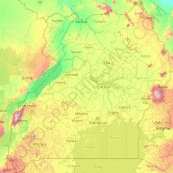
Name: Uganda topographic map, elevation, terrain.

Location: Uganda (-1.48232 29.57343 4.23408 35.00031)

Average elevation: 1,157 m

Minimum elevation: 500 m

Maximum elevation: 4,464 m

Other topographic maps

Click on a map to view its topography, its elevation and its terrain.

Kisoro

Uganda > Kisoro > Cyanika > Kisoro

Kisoro, Cyanika, Kisoro, Western Region, PO BOX 22, Uganda

Average elevation: 1,911 m

Zambia

Uganda > Arua > Zambia

Zambia, Arua, Northern Region, 481, Uganda

Average elevation: 1,177 m

Busia

Uganda > Busia

Busia, Eastern Region, Uganda

Average elevation: 1,168 m

Northern Region

Uganda > Northern Region

Northern Region, Uganda

Average elevation: 1,004 m

Budadiri

Uganda > Sironko > Budadiri

Budadiri, Bugisa sub-region, Sironko, Eastern Region, Uganda

Average elevation: 1,276 m

Jinja

Uganda > Jinja

Jinja, Eastern Region, Uganda

Average elevation: 1,150 m

Makindye

Uganda > Kampala > Makindye

Makindye, Kampala, Central Region, Uganda

Average elevation: 1,160 m

Amemya

Uganda > Amuria > Amemya

Amemya, Amuria, Eastern Region, Uganda

Average elevation: 1,066 m

Manibe

Uganda > Arua > Manibe

Manibe, Arua, Northern Region, Uganda

Average elevation: 1,149 m

Mawanga

Uganda > Butaleja > Mawanga

Mawanga, Butaleja, Eastern Region, Uganda

Average elevation: 1,079 m

Mount Elgon

Uganda > Bukwo > Bukwo

Mount Elgon, Bukwo, Eastern Region, Uganda

Average elevation: 3,762 m

Lake Albert

Uganda > Hoima > Hoima

Lake Albert, Hoima, Western Region, Uganda

Average elevation: 1,076 m

Mount Luigi di Savoia

Uganda > Kasese > Kasese

Mount Luigi di Savoia, South Ridge Route, Kasese, Western Region, Uganda

Average elevation: 4,114 m

Iringa

Uganda > Buyende > Iringa

Iringa, Buyende, Eastern Region, Uganda

Average elevation: 1,054 m

Mount Morungole

Uganda > Kaabong

Mount Morungole, Kaabong, Northern Region, Uganda

Average elevation: 2,388 m

Pupu

Uganda > Abim > Pupu

Pupu, Labwor, Abim, Northern Region, Uganda

Average elevation: 1,126 m

Kigoma

Uganda > Kibaale > Kigoma

Kigoma, Kibaale, Western Region, Uganda

Average elevation: 1,110 m

Kavango

Uganda > Nebbi

Kavango, Nebbi, Northern Region, Uganda

Average elevation: 620 m

Mount Kadam

Uganda > Nakapiripirit

Mount Kadam, Nakapiripirit, Northern Region, Uganda

Average elevation: 2,532 m

Rwenzori Mountains

Uganda > Bundibugyo > Sindila

Rwenzori Mountains, Sindila, Bundibugyo, Western Region, Uganda

Average elevation: 1,570 m

Moroto

Uganda > Moroto

Moroto, Northern Region, Uganda

Average elevation: 1,239 m

Mbare

Uganda > Isingiro > Mbare

Nshororo, Mbare, Buganza, Isingiro, Western Region, Uganda

Average elevation: 1,316 m

Nakapiripirit

Uganda > Nakapiripirit

Nakapiripirit, Northern Region, Uganda

Average elevation: 1,270 m

Mount Moroto

Uganda > Moroto

Mount Moroto, Moroto, Northern Region, Uganda

Average elevation: 2,697 m

Central Region

Uganda > Central Region

Central Region, Uganda

Average elevation: 1,230 m

Nyanja

Uganda > Isingiro > Endiinzi > Nyabyondo

Nyanja, Nyabyondo, Endiinzi, Buganza, Isingiro, Western Region, Uganda

Average elevation: 1,338 m

Kasese

Uganda > Kasese

Kasese, Western Region, Uganda

Average elevation: 1,457 m

Coronation Glacier

Uganda > Kasese > Kasese

Coronation Glacier, South Ridge Route, Kasese, Western Region, Uganda

Average elevation: 4,405 m

Mukarange;Block 84

Uganda > Hoima > Mukarange;Block 84

Mukarange;Block 84, Hoima, Western Region, Uganda

Average elevation: 1,130 m