
Gunung Ijen topographic map
Interactive map
Click on the map to display elevation.
About this map
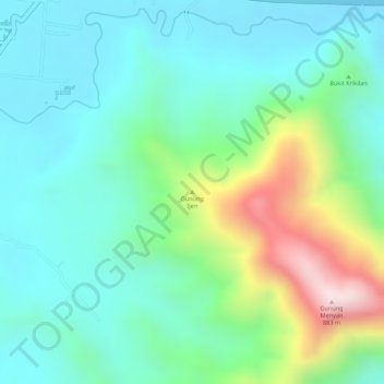
Name: Gunung Ijen topographic map, elevation, terrain.
Location: Gunung Ijen, Banyuwangi, East Java, Indonesia (-8.31265 113.98925 -8.31255 113.98935)
Average elevation: 509 m
Minimum elevation: 376 m
Maximum elevation: 846 m
Other topographic maps
Click on a map to view its topography, its elevation and its terrain.
Kawah Ijen Crater Lake
Indonesia > East Java > Banyuwangi
Kawah Ijen Crater Lake, Banyuwangi, East Java, Indonesia
Average elevation: 2,175 m