
Springtown topographic map
Interactive map
Click on the map to display elevation.
About this map
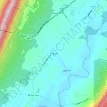
Name: Springtown topographic map, elevation, terrain.
Average elevation: 289 m
Minimum elevation: 217 m
Maximum elevation: 572 m
Other topographic maps
Click on a map to view its topography, its elevation and its terrain.
Fannettsburg
United States > Pennsylvania > Franklin County > Metal Township
Fannettsburg, Metal Township, Franklin County, Pennsylvania, 17221, United States
Average elevation: 291 m
Richmond Furnace
United States > Pennsylvania > Franklin County > Metal Township
Richmond Furnace, Metal Township, Franklin County, Pennsylvania, 17224, United States
Average elevation: 340 m
Willow Hill
United States > Pennsylvania > Franklin County > Metal Township
Willow Hill, Metal Township, Franklin County, Pennsylvania, 17271, United States
Average elevation: 275 m
Cowans Gap
United States > Pennsylvania > Franklin County > Metal Township > Cowans Village
Cowans Gap, Cowans Village, Metal Township, Franklin County, Pennsylvania, 17224, United States
Average elevation: 402 m