
Takasaki topographic map
Interactive map
Click on the map to display elevation.
About this map
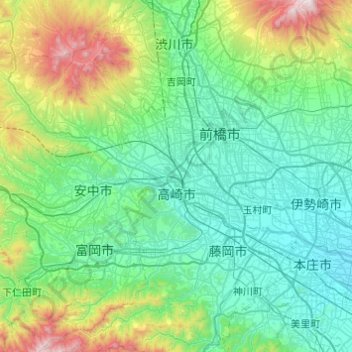
Name: Takasaki topographic map, elevation, terrain.
Location: Takasaki, Gunma Prefecture, Japan (36.19859 138.64251 36.48347 139.12966)
Average elevation: 331 m
Minimum elevation: 36 m
Maximum elevation: 1,555 m
Takasaki is located in the southwestern part of Gunma Prefecture in the flat northwestern part of the Kantō Plain. The city is located approximately 90 to 100 kilometers from central Tokyo . Mount Akagi, Mount Haruna and Mount Myogi can be seen from the city, and the southern slopes of Mount Haruna are within the city limits. The Tone River, Karasu River and Usui River flow through the city. Although Takasaki is located over 100 kilometers from the coast, much of the city is low-lying, and the elevation of the city hall and central city area is only 97 meters above sea level. The land rises to the northern and western parts of the city to a maximum elevation of 1690 meters.
Other topographic maps
Click on a map to view its topography, its elevation and its terrain.
Mount Fuji
Japan > Sunto County > Oyama
Mount Fuji, Oyama, Sunto County, Shizuoka Prefecture, Chubu Region, Japan
Average elevation: 3,261 m
Nishi Mera
Nishi Mera, Koyu County, Miyazaki Prefecture, Japan
Average elevation: 656 m
Lake Ashi
Japan > Ashigarashimo County > Hakone
Lake Ashi, Hakone, Ashigarashimo County, Kanagawa Prefecture, Japan
Average elevation: 869 m
Maborikaigan 4-chome Park
Maborikaigan 4-chome Park, Maboricho 3-chome, Yokosuka, Kanagawa Prefecture, 238-8550, Japan
Average elevation: 22 m
Ibaraki
Ibaraki, Higashiibaraki County, Ibaraki Prefecture, 311-3116, Japan
Average elevation: 26 m
Lake Sanaru
Lake Sanaru, Hamamatsu, Shizuoka Prefecture, Chubu Region, Japan
Average elevation: 16 m
Motoyama
Motoyama, Nagaoka County, Kochi Prefecture, 781-3601, Japan
Average elevation: 679 m
Setouchi
Setouchi, Oshima County, Kagoshima Prefecture, Japan
Average elevation: 26 m
Higashishirakawa
Higashishirakawa, Kamo County, Gifu Prefecture, Chubu Region, 509-1392, Japan
Average elevation: 658 m
Nishikigaoka-chuo Park
Nishikigaoka-chuo Park, Nishikigaoka 2-chome, Aoba Ward, Sendai, Miyagi Prefecture, Japan
Average elevation: 197 m