
Dover Plains topographic map
Interactive map
Click on the map to display elevation.
About this map
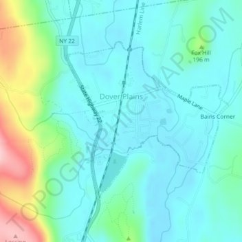
Name: Dover Plains topographic map, elevation, terrain.
Average elevation: 149 m
Minimum elevation: 108 m
Maximum elevation: 296 m
Other topographic maps
Click on a map to view its topography, its elevation and its terrain.
Beacon Hills
United States > New York > Dutchess County > Town of Fishkill
Beacon Hills, Town of Fishkill, Dutchess County, New York, 12527, United States
Average elevation: 158 m
Drayton Grant Park at Burger Hill
United States > New York > Dutchess County > Town of Rhinebeck
Drayton Grant Park at Burger Hill, Town of Rhinebeck, Dutchess County, New York, United States
Average elevation: 102 m
United States of America Property
United States > New York > Dutchess County > Village of Pawling
United States of America Property, West Dover Road, Village of Pawling, Town of Pawling, Town of Dover, Dutchess County, New York, 12564, United States
Average elevation: 251 m
Town of Pawling
United States > New York > Dutchess County
Town of Pawling, Dutchess County, New York, United States
Average elevation: 243 m
City of Beacon
United States > New York > Dutchess County
City of Beacon, Dutchess County, New York, 12508, United States
Average elevation: 68 m
Titusville
United States > New York > Dutchess County
Titusville, Town of La Grange, Dutchess County, New York, United States
Average elevation: 65 m
Clinton Corners
United States > New York > Dutchess County
Clinton Corners, Town of Clinton, Dutchess County, New York, 12514, United States
Average elevation: 114 m
Town of Beekman
United States > New York > Dutchess County
Town of Beekman, Dutchess County, New York, 12570, United States
Average elevation: 194 m
Rhinecliff
United States > New York > Dutchess County > Town of Rhinebeck
Rhinecliff, Town of Rhinebeck, Dutchess County, New York, 12574, United States
Average elevation: 19 m
Shorehaven
United States > New York > Dutchess County > Town of Pawling
Shorehaven, Town of Pawling, Dutchess County, New York, United States
Average elevation: 292 m
Barrytown
United States > New York > Dutchess County > Town of Red Hook
Barrytown, Town of Red Hook, Dutchess County, New York, 12507, United States
Average elevation: 26 m
Bangall
United States > New York > Dutchess County
Bangall, Town of Stanford, Dutchess County, New York, 12506, United States
Average elevation: 172 m
Leedsville
United States > New York > Dutchess County > Town of Amenia
Leedsville, Town of Amenia, Dutchess County, New York, 12501, United States
Average elevation: 191 m
Sharon Station
United States > New York > Dutchess County
Sharon Station, Town of North East, Dutchess County, New York, 12501, United States
Average elevation: 206 m
South Amenia
United States > New York > Dutchess County > Town of Amenia
South Amenia, Town of Amenia, Dutchess County, New York, 12592, United States
Average elevation: 186 m
Annandale-on-Hudson
United States > New York > Dutchess County > Town of Red Hook
Annandale-on-Hudson, Town of Red Hook, Dutchess County, New York, 12504, United States
Average elevation: 43 m
Myers Corner
United States > New York > Dutchess County
Myers Corner, Town of Wappinger, Dutchess County, New York, 12590, United States
Average elevation: 75 m
Timothy Heights
United States > New York > Dutchess County > Town of Pleasant Valley
Timothy Heights, Town of Pleasant Valley, Dutchess County, New York, 12569, United States
Average elevation: 87 m
Village of Tivoli
United States > New York > Dutchess County
Village of Tivoli, Town of Red Hook, Dutchess County, New York, United States
Average elevation: 38 m
Bulls Head
United States > New York > Dutchess County
Bulls Head, Town of Clinton, Dutchess County, New York, 12514, United States
Average elevation: 150 m
Shenandoah
United States > New York > Dutchess County > Town of East Fishkill
Shenandoah, Town of East Fishkill, Dutchess County, New York, 12533, United States
Average elevation: 153 m
Town of Red Hook
United States > New York > Dutchess County
Town of Red Hook, Dutchess County, New York, United States
Average elevation: 62 m
Howland
United States > New York > Dutchess County
Howland, Town of Poughkeepsie, Dutchess County, New York, United States, Mapleknoll Marsh
Average elevation: 37 m
Knapps Corner
United States > New York > Dutchess County
Knapps Corner, Town of Poughkeepsie, Dutchess County, New York, 12590, United States
Average elevation: 48 m
Barnegat
United States > New York > Dutchess County
Barnegat, Town of Poughkeepsie, Dutchess County, New York, 12547, United States
Average elevation: 45 m
Village of Rhinebeck
United States > New York > Dutchess County
Village of Rhinebeck, Town of Rhinebeck, Dutchess County, New York, United States
Average elevation: 55 m
Town of Pine Plains
United States > New York > Dutchess County
Town of Pine Plains, Dutchess County, New York, 12567, United States
Average elevation: 205 m
Mirror Lake
United States > New York > Dutchess County > Town of Milan
Mirror Lake, Town of Milan, Dutchess County, New York, United States
Average elevation: 190 m
Netherwood
United States > New York > Dutchess County > Town of Pleasant Valley
Netherwood, Town of Pleasant Valley, Dutchess County, New York, 12578, United States
Average elevation: 110 m
Cokertown
United States > New York > Dutchess County > Town of Red Hook
Cokertown, Town of Red Hook, Dutchess County, New York, 12571, United States
Average elevation: 106 m
Bald Hill
United States > New York > Dutchess County > Town of Fishkill
Bald Hill, Town of Fishkill, Dutchess County, New York, 12527, United States
Average elevation: 223 m
Town of Poughkeepsie
United States > New York > Dutchess County
Town of Poughkeepsie, Dutchess County, New York, United States
Average elevation: 80 m
Haviland
United States > New York > Dutchess County > Town of Hyde Park
Haviland, Town of Hyde Park, Dutchess County, New York, 12538, United States
Average elevation: 84 m
Village of Millerton
United States > New York > Dutchess County
Village of Millerton, Town of North East, Dutchess County, New York, United States
Average elevation: 243 m
Town of North East
United States > New York > Dutchess County
Town of North East, Dutchess County, New York, 12546, United States
Average elevation: 267 m
Pleasant Ridge
United States > New York > Dutchess County
Pleasant Ridge, Town of Union Vale, Dutchess County, New York, 12570, United States
Average elevation: 317 m
Webatuck
United States > New York > Dutchess County
Webatuck, Town of Dover, Dutchess County, New York, 12594, United States
Average elevation: 157 m
Smithfield
United States > New York > Dutchess County > Town of Amenia
Smithfield, Town of Amenia, Dutchess County, New York, United States
Average elevation: 297 m
Holmes
United States > New York > Dutchess County > Town of Pawling
Holmes, Town of Pawling, Dutchess County, New York, 12531, United States
Average elevation: 247 m
Arlington
United States > New York > Dutchess County
Arlington, Town of Poughkeepsie, Dutchess County, New York, United States
Average elevation: 60 m
Salt Point
United States > New York > Dutchess County > Town of Pleasant Valley
Salt Point, Town of Pleasant Valley, Dutchess County, New York, 12578, United States
Average elevation: 97 m
Town of Hyde Park
United States > New York > Dutchess County
Town of Hyde Park, Dutchess County, New York, United States
Average elevation: 93 m
Town of East Fishkill
United States > New York > Dutchess County
Town of East Fishkill, Dutchess County, New York, United States
Average elevation: 142 m
Town of Dover
United States > New York > Dutchess County
Town of Dover, Dutchess County, New York, United States
Average elevation: 230 m
Stormville
United States > New York > Dutchess County > Town of East Fishkill
Stormville, Town of East Fishkill, Dutchess County, New York, 12582, United States
Average elevation: 112 m
Glenham
United States > New York > Dutchess County > Town of Fishkill
Glenham, Town of Fishkill, Dutchess County, New York, 12527, United States
Average elevation: 108 m
Lagrangeville
United States > New York > Dutchess County
Lagrangeville, Town of La Grange, Dutchess County, New York, 12540, United States
Average elevation: 138 m
Town of Milan
United States > New York > Dutchess County
Town of Milan, Dutchess County, New York, United States
Average elevation: 149 m
Town of Rhinebeck
United States > New York > Dutchess County
Town of Rhinebeck, Dutchess County, New York, United States
Average elevation: 66 m
Town of Amenia
United States > New York > Dutchess County
Town of Amenia, Dutchess County, New York, United States
Average elevation: 256 m