
Cedarburg topographic map
Interactive map
Click on the map to display elevation.
About this map
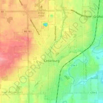
Name: Cedarburg topographic map, elevation, terrain.
Location: Cedarburg, Ozaukee County, Wisconsin, 53012, United States (43.27441 -88.01448 43.32830 -87.95044)
Average elevation: 247 m
Minimum elevation: 201 m
Maximum elevation: 293 m
Other topographic maps
Click on a map to view its topography, its elevation and its terrain.
Grafton Centennial Park
United States > Wisconsin > Ozaukee County > Grafton
Grafton Centennial Park, Grafton, Town of Grafton, Ozaukee County, Wisconsin, United States
Average elevation: 232 m
Saukville
United States > Wisconsin > Ozaukee County
Saukville, Ozaukee County, Wisconsin, 53080, United States
Average elevation: 238 m
Mequon
United States > Wisconsin > Ozaukee County
Mequon, Ozaukee County, Wisconsin, United States
Average elevation: 223 m
Harrington Beach State Park
United States > Wisconsin > Ozaukee County > Lake Church
Harrington Beach State Park, Lake Church, Town of Belgium, Ozaukee County, Wisconsin, United States
Average elevation: 194 m
Fredonia
United States > Wisconsin > Ozaukee County
Fredonia, Ozaukee County, Wisconsin, United States
Average elevation: 251 m
Town of Grafton
United States > Wisconsin > Ozaukee County
Town of Grafton, Ozaukee County, Wisconsin, United States
Average elevation: 203 m
Port Washington
United States > Wisconsin > Ozaukee County
Port Washington, Ozaukee County, Wisconsin, 53074, United States
Average elevation: 205 m
Port Washington
United States > Wisconsin > Ozaukee County > Port Washington > Port Washington
Port Washington, Ozaukee County, Wisconsin, 53074, United States
Average elevation: 205 m
Decker Corner
United States > Wisconsin > Ozaukee County > Decker Corner
Decker Corner, Town of Cedarburg, Ozaukee County, Wisconsin, United States
Average elevation: 262 m
Cedar Creek
United States > Wisconsin > Ozaukee County
Cedar Creek, Ozaukee County, Wisconsin, 53202-3519, United States
Average elevation: 250 m
Grafton
United States > Wisconsin > Ozaukee County
Grafton, Ozaukee County, Wisconsin, 53024, United States
Average elevation: 238 m