
Sylt topographic map
Interactive map
Click on the map to display elevation.
About this map
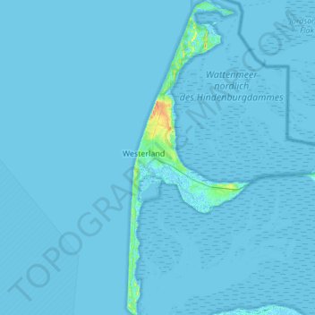
Name: Sylt topographic map, elevation, terrain.
Location: Sylt, Nordfriesland, Sleeswijk-Holstein, Duitsland (54.74441 8.27846 55.05866 8.48996)
Average elevation: 0 m
Minimum elevation: -2 m
Maximum elevation: 37 m
Other topographic maps
Click on a map to view its topography, its elevation and its terrain.
Westerland
Duitsland > Sleeswijk-Holstein > Sylt
Westerland, Sylt, Nordfriesland, Sleeswijk-Holstein, Duitsland
Average elevation: 3 m