
Le Breuil topographic map
Interactive map
Click on the map to display elevation.
About this map
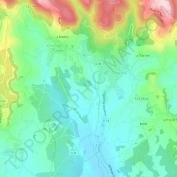
Name: Le Breuil topographic map, elevation, terrain.
Average elevation: 225 m
Minimum elevation: 134 m
Maximum elevation: 440 m
Other topographic maps
Click on a map to view its topography, its elevation and its terrain.
Le Martret
France > Nouvelle-Aquitaine > Corrèze > Collonges-la-Rouge
Le Martret, Collonges-la-Rouge, Brive-la-Gaillarde, Corrèze, Nouvelle-Aquitaine, France métropolitaine, 19500, France
Average elevation: 288 m
Langlade
France > Nouvelle-Aquitaine > Corrèze > Collonges-la-Rouge
Langlade, Collonges-la-Rouge, Brive-la-Gaillarde, Corrèze, Nouvelle-Aquitaine, France métropolitaine, 19500, France
Average elevation: 304 m
La Gondrone
France > Nouvelle-Aquitaine > Corrèze > Collonges-la-Rouge
La Gondrone, Collonges-la-Rouge, Brive-la-Gaillarde, Corrèze, Nouvelle-Aquitaine, France métropolitaine, 19500, France
Average elevation: 202 m
Manoir de Beauvirie
France > Nouvelle-Aquitaine > Corrèze > Collonges-la-Rouge > Le Martret
Manoir de Beauvirie, Rue Noire, Le Martret, Collonges-la-Rouge, Brive-la-Gaillarde, Corrèze, Nouvelle-Aquitaine, France métropolitaine, 19500, France
Average elevation: 266 m