
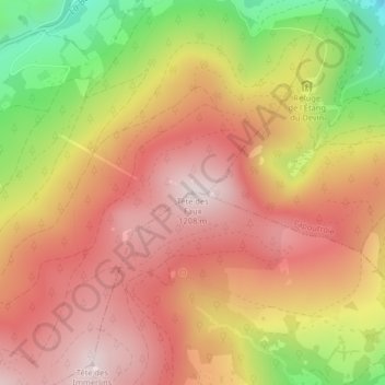
Tête des Faux topographic map
Interactive map
Click on the map to display elevation.
About this map
Name: Tête des Faux topographic map, elevation, terrain.
Average elevation: 994 m
Minimum elevation: 661 m
Maximum elevation: 1,204 m
Other topographic maps
Click on a map to view its topography, its elevation and its terrain.
Les Basses Huttes
France > Grand Est > Haut-Rhin > Orbey
Les Basses Huttes, Orbey, Colmar-Ribeauvillé, Haut-Rhin, Grand Est, France métropolitaine, 68370, France
Average elevation: 809 m
Les Hautes-Huttes
France > Grand Est > Haut-Rhin > Orbey
Les Hautes-Huttes, Orbey, Colmar-Ribeauvillé, Haut-Rhin, Grand Est, France métropolitaine, 68370, France
Average elevation: 868 m
Auberge-Refuge Le Blancrupt
France > Grand Est > Haut-Rhin > Orbey
Auberge-Refuge Le Blancrupt, D 48II, Orbey, Colmar-Ribeauvillé, Haut-Rhin, Grand Est, France métropolitaine, 68370, France
Average elevation: 1,080 m