
Oyoor topographic map
Interactive map
Click on the map to display elevation.
About this map
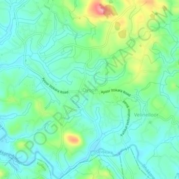
Name: Oyoor topographic map, elevation, terrain.
Location: Oyoor, Kottarakkara, Kollam District, Kerala, 691510, India (8.85483 76.75348 8.89483 76.79348)
Average elevation: 40 m
Minimum elevation: 6 m
Maximum elevation: 133 m
Other topographic maps
Click on a map to view its topography, its elevation and its terrain.
Madathara
India > Kerala > Kottarakkara
Madathara, Kottarakkara, Kollam District, Kerala, 691541, India
Average elevation: 180 m
Kizhakkumbhagom kulam
India > Kerala > Kottarakkara > Chithara
Kizhakkumbhagom kulam, Chithara, Kottarakkara, Kollam District, Kerala, India
Average elevation: 163 m
Kalayapuram
India > Kerala > Kottarakkara > Kalayapuram
Kalayapuram, Kottarakkara, Kollam, Kerala, 691560, India
Average elevation: 40 m
Veliyam
India > Kerala > Kottarakkara > Veliyam
Veliyam, Kottarakkara, Kollam, Kerala, 691540, India
Average elevation: 44 m
Kottarakkara
India > Kerala > Kottarakkara
Kottarakkara, Kollam, Kerala, 691500, India
Average elevation: 54 m