
Gmunden topographic map
Interactive map
Click on the map to display elevation.
Gmunden
Gmunden covers an area of 63.49 square kilometres (24.51 sq mi) and has a median elevation of 425 metres (1,394 ft). It is situated next to the lake Traunsee on the Traun River and is surrounded by high mountains, including the Traunstein (mountain) (5,446 feet or 1,660 metres), the Erlakogel (5150 ft), the Wilder Kogel (6,860 feet or 2,090 metres) and the Höllengebirge.
About this map
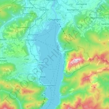
Name: Gmunden topographic map, elevation, terrain.
Location: Gmunden, Upper Austria, 4810, Austria (47.81858 13.77477 47.94020 13.90030)
Average elevation: 692 m
Minimum elevation: 414 m
Maximum elevation: 1,645 m