
Bhojpur topographic map
Interactive map
Click on the map to display elevation.
About this map
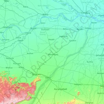
Name: Bhojpur topographic map, elevation, terrain.
Location: Bhojpur, Rohtas District, Bihar, India (24.55000 83.55000 25.95000 84.95000)
Average elevation: 104 m
Minimum elevation: 44 m
Maximum elevation: 635 m
Other topographic maps
Click on a map to view its topography, its elevation and its terrain.
Jagdispur
India > Bihar > Jagdishpur
Jagdispur, Jagdishpur, Bhojpur District, Bihar, 802158, India
Average elevation: 68 m
Kishanganj
India > Bihar > Kishanganj
Kishanganj, Kishanganj District, Bihar, 855107, India
Average elevation: 48 m
Purnia
India > Bihar > Purnia East
Purnia, Purnia East, Purnia District, Bihar, 854301, India
Average elevation: 38 m
Sheikhpura
India > Bihar > Sheikhpura
Sheikhpura, Sheikhpura District, Bihar, 803109, India
Average elevation: 49 m
Sonbhadra
India > Bihar > Sonbhadra Banshi Suryapur
Sonbhadra, Sonbhadra Banshi Suryapur, Arwal District, Bihar, 824120, India
Average elevation: 74 m
10
India > Bihar > Patna Rural > Patna
10, Patna, Patna Rural, Patna District, Bihar, 800001, India
Average elevation: 54 m
Patna
India > Bihar > Patna Rural
Patna, Patna Rural, Patna District, Bihar, 800001, India
Average elevation: 51 m
Rajgir Forests
Rajgir Forests, Muhra, Gaya, Bihar, 805112, India
Average elevation: 95 m