
Rhyl topographic map
Interactive map
Click on the map to display elevation.
About this map
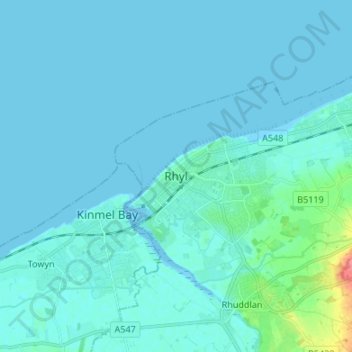
Name: Rhyl topographic map, elevation, terrain.
Location: Rhyl, Denbighshire, Wales, LL18 1RG, United Kingdom (53.28074 -3.53073 53.36074 -3.45073)
Average elevation: 5 m
Minimum elevation: -2 m
Maximum elevation: 59 m
Other topographic maps
Click on a map to view its topography, its elevation and its terrain.
Y Berwyn National Nature Reserve
United Kingdom > Wales > Denbighshire
Y Berwyn National Nature Reserve, Llandrillo, Denbighshire, Wales, LL21 0TE, United Kingdom
Average elevation: 455 m
Prestatyn
United Kingdom > Wales > Denbighshire
Prestatyn, Denbighshire, Wales, LL19 9LG, United Kingdom
Average elevation: 48 m
Aberwheeler
United Kingdom > Wales > Denbighshire > Bodfari
Aberwheeler, Bodfari, Denbighshire, Wales, LL16 4BT, United Kingdom
Average elevation: 97 m
Corwen
United Kingdom > Wales > Denbighshire
Corwen, Denbighshire, Wales, LL21 0DL, United Kingdom
Average elevation: 274 m
Denbigh
United Kingdom > Wales > Denbighshire
Denbigh, Denbighshire, Wales, LL16 3UN, United Kingdom
Average elevation: 102 m
Ruthin
United Kingdom > Wales > Denbighshire > Ruthin
Ruthin, Denbighshire, Wales, LL15 1BU, United Kingdom
Average elevation: 162 m