
Khan Daun Penh topographic map
Interactive map
Click on the map to display elevation.
About this map
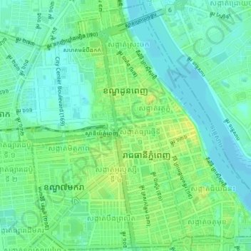
Name: Khan Daun Penh topographic map, elevation, terrain.
Location: Khan Daun Penh, Phnom Penh, Cambodia (11.55563 104.90392 11.58957 104.93960)
Average elevation: 13 m
Minimum elevation: 5 m
Maximum elevation: 24 m
Other topographic maps
Click on a map to view its topography, its elevation and its terrain.
Phum Kien Khleang
Cambodia > Phnom Penh > Khan Chroy Changvar > Sangkat Chroy Changvar
Average elevation: 9 m