
Mores pagasts topographic map
Interactive map
Click on the map to display elevation.
About this map
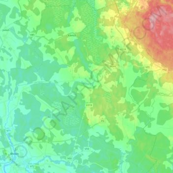
Name: Mores pagasts topographic map, elevation, terrain.
Location: Mores pagasts, Siguldas novads, Vidzeme, LV-2170, Latvia (57.00134 24.97434 57.13102 25.15707)
Average elevation: 117 m
Minimum elevation: 80 m
Maximum elevation: 216 m
Other topographic maps
Click on a map to view its topography, its elevation and its terrain.
Sunīši
Latvia > Vidzeme > Siguldas novads > Krimuldas pagasts
Sunīši, Krimuldas pagasts, Siguldas novads, Vidzeme, Latvia
Average elevation: 49 m
Sunīši
Latvia > Vidzeme > Siguldas novads > Sunīši
Sunīši, Siguldas novads, Vidzeme, LV-2144, Latvia
Average elevation: 46 m
Krimuldas novads
Latvia > Vidzeme > Siguldas novads
Krimuldas novads, Siguldas novads, Vidzeme, Latvia
Average elevation: 64 m