
Meadows topographic map
Interactive map
Click on the map to display elevation.
About this map
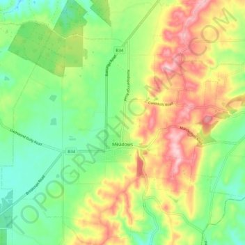
Name: Meadows topographic map, elevation, terrain.
Average elevation: 368 m
Minimum elevation: 286 m
Maximum elevation: 484 m
Other topographic maps
Click on a map to view its topography, its elevation and its terrain.
Mount Barker
Australia > South Australia > Mount Barker District Council > Mount Barker
Mount Barker, Mount Barker District Council, South Australia, 5251, Australia
Average elevation: 368 m
Hahndorf
Australia > South Australia > Mount Barker District Council
Hahndorf, Mount Barker District Council, South Australia, 5245, Australia
Average elevation: 371 m