
Arnstein topographic map
Interactive map
Click on the map to display elevation.
About this map
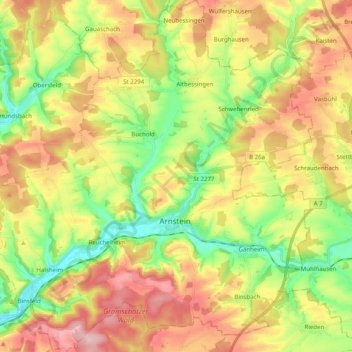
Name: Arnstein topographic map, elevation, terrain.
Location: Arnstein, Landkreis Main-Spessart, Beieren, 97450, Duitsland (49.93057 9.86463 50.05794 10.04609)
Average elevation: 282 m
Minimum elevation: 192 m
Maximum elevation: 385 m
Other topographic maps
Click on a map to view its topography, its elevation and its terrain.
Zellingen
Duitsland > Beieren > Landkreis Main-Spessart
Zellingen, Verwaltungsgemeinschaft Zellingen, Landkreis Main-Spessart, Beieren, 97225, Duitsland
Average elevation: 262 m
Roden
Duitsland > Beieren > Landkreis Main-Spessart
Roden, Verwaltungsgemeinschaft Marktheidenfeld, Landkreis Main-Spessart, Beieren, 97849, Duitsland
Average elevation: 287 m