
Roanoke topographic map
Interactive map
Click on the map to display elevation.
About this map
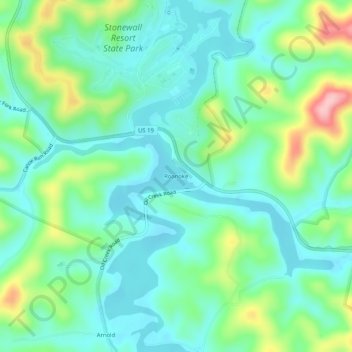
Name: Roanoke topographic map, elevation, terrain.
Location: Roanoke, Lewis County, West Virginia, 26447, United States (38.91176 -80.51287 38.95176 -80.47287)
Average elevation: 366 m
Minimum elevation: 320 m
Maximum elevation: 491 m
Other topographic maps
Click on a map to view its topography, its elevation and its terrain.
Jacksonville
United States > West Virginia > Lewis County
Jacksonville, Lewis County, West Virginia, United States
Average elevation: 364 m
Weston
United States > West Virginia > Lewis County
Weston, Lewis County, West Virginia, 26452, United States
Average elevation: 359 m