
Zwickgabel topographic map
Interactive map
Click on the map to display elevation.
About this map
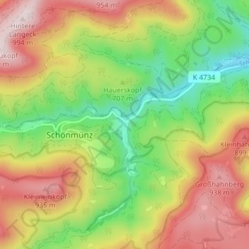
Name: Zwickgabel topographic map, elevation, terrain.
Average elevation: 728 m
Minimum elevation: 496 m
Maximum elevation: 987 m
Other topographic maps
Click on a map to view its topography, its elevation and its terrain.
Tonbach
Duitsland > Baden-Württemberg > Landkreis Freudenstadt > Baiersbronn
Tonbach, Baiersbronn, Landkreis Freudenstadt, Baden-Württemberg, 72270, Duitsland
Average elevation: 675 m